IMAGES TAKEN NEAR TO
Lythe, WHITBY, YO21 3RR
Introduction
This page details the photographs taken nearby to YO21 3RR by members of the Geograph project.
The Geograph project started in 2005 with the aim of publishing, organising and preserving representative images for every square kilometre of Great Britain, Ireland and the Isle of Man.

There are currently over 7.5m images from over14,400 individuals and you can help contribute to the project by visiting https://www.geograph.org.uk
Image Map
Images are licensed for reuse under creativecommons.org/licenses/by-sa/2.0
Notes
- Clicking on the map will re-center to the selected point.
- The higher the marker number, the further away the image location is from the centre of the postcode.
Image Listing (6 Images Found)
Images are licensed for reuse under creativecommons.org/licenses/by-sa/2.0
Image
Details
Distance
1
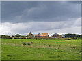
Deepgrove Farm
Looking east from the rim of Deep Grove alum quarries
Image: © Stephen McCulloch
Taken: 13 Aug 2007
0.03 miles
2
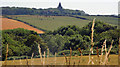
Trees in Overdale, North Yorks.
The Overdale beck has cut a valley between the Overdale headland (from where the photograph was taken), and Deepgrove, the sloping fields seen beyond the trees. The valley is wooded for about 2 km.
The church in the distance is St. Oswald's C. of E., Lythe.
Image: © Peter Church
Taken: 18 Jul 2006
0.17 miles
4
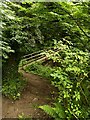
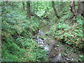
Footpath and footbridge, Overdale
Heading south towards Deepgrove Farm.
Image: © Stephen McCulloch
Taken: 13 Aug 2007
0.20 miles
6
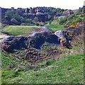
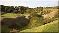
Deep Grove Quarries
In the past, this area was extensively quarried for alum, used in the textile industry.
Image: © Pauline E
Taken: 24 Apr 2014
0.23 miles