IMAGES TAKEN NEAR TO
Derwent Road, WHITBY, YO21 3LU
Introduction
This page details the photographs taken nearby to Derwent Road, YO21 3LU by members of the Geograph project.
The Geograph project started in 2005 with the aim of publishing, organising and preserving representative images for every square kilometre of Great Britain, Ireland and the Isle of Man.

There are currently over 7.5m images from over14,400 individuals and you can help contribute to the project by visiting https://www.geograph.org.uk
Image Map
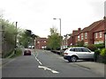
Images are licensed for reuse under creativecommons.org/licenses/by-sa/2.0
Notes
- Clicking on the map will re-center to the selected point.
- The higher the marker number, the further away the image location is from the centre of the postcode.
Image Listing (19 Images Found)
Images are licensed for reuse under creativecommons.org/licenses/by-sa/2.0
Image
Details
Distance

2

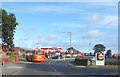
Stakesby Garage
Busy garage in north Whitby on Stakesby Road.
Image: © Darren Haddock
Taken: 9 Sep 2006
0.12 miles
3
Spar petrol station and Lidl entrance
Castle Road, heading into Whitby.
Image: © Pauline E
Taken: 9 Oct 2013
0.14 miles
4
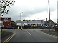
Love Lane running down to Castle Road
Image: © Steve Daniels
Taken: 18 May 2016
0.15 miles
5
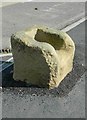
Old Wayside Cross by the B1460, Stakesby Road, Whitby
Wishing Chair Cross, old base by the B1460, in parish of Whitby (Scarborough District), Stakesby Road, between junction with Love Lane and Westbourne Road (opposite The new Sanctuary Cross made for the Festival of Britain), by supermarket, in pavement (a mile from Whitby Abbey).
Scheduled Monument.
List Entry Number: 1009851 https://historicengland.org.uk/listing/the-list/list-entry/1009851
Surveyed
Milestone Society National ID: YNSC_WHI03
Image: © Milestone Society
Taken: Unknown
0.15 miles
6

Guisborough 21
Old milepost on what was the A.171 at Whitby, North Yorkshire. For overall view see http://www.geograph.org.uk/photo/1904115
Image: © Keith Evans
Taken: 2 Jun 2010
0.18 miles
7

The Avenue, Whitby
The Avenue is a residential road in Whitby.
Image: © Malc McDonald
Taken: 29 Apr 2021
0.19 miles
8
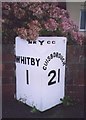
Old Milepost by the A171, Castle Road, Whitby
Milepost by the A171, in parish of Whitby (Scarborough District), Castle Road, Whitby, on bend opposite B1416 junction, outside No.15.
Inscription reads:-
: WHITBY / 1 : : NRYCC : : GUISBOROUGH / 21 :
Maker:-
: F MATTISON & Co / BEDALE :
North Yorkshire HER.
NY SMR Number: MNY36619 https://www.heritagegateway.org.uk/Gateway/Results_Single.aspx?uid=MNY36619&resourceID=1009
Milestone Society National ID: YN_WYGU01
Image: © Milestone Society
Taken: Unknown
0.19 miles
10
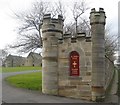
Sneaton Castle and St Hilda's Priory (4)
The opposite wall of the lodge/gatehouse entrance in Castle Road.
Image: © Mike Kirby
Taken: 16 Feb 2012
0.19 miles