IMAGES TAKEN NEAR TO
Normanby Terrace, WHITBY, YO21 3ES
Introduction
This page details the photographs taken nearby to Normanby Terrace, YO21 3ES by members of the Geograph project.
The Geograph project started in 2005 with the aim of publishing, organising and preserving representative images for every square kilometre of Great Britain, Ireland and the Isle of Man.

There are currently over 7.5m images from over14,400 individuals and you can help contribute to the project by visiting https://www.geograph.org.uk
Image Map
Images are licensed for reuse under creativecommons.org/licenses/by-sa/2.0
Notes
- Clicking on the map will re-center to the selected point.
- The higher the marker number, the further away the image location is from the centre of the postcode.
Image Listing (1082 Images Found)
Images are licensed for reuse under creativecommons.org/licenses/by-sa/2.0
Image
Details
Distance
1
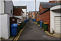
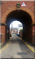
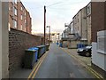
Back passage in Whitby
This is where everyone keeps their bins.
Image: © Bill Boaden
Taken: 3 Sep 2014
0.01 miles
2
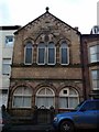
Masonic Hall - John Street
Interesting and familiar symbols on the street frontage.
From: http://www.lionlodge.org/
The Whitby Gazette in its issue dated 20/8/1859 reported: “The Consecration of the Masonic Hall”
This interesting event took place on Tuesday the 16th inst. at 2 o’clock in the afternoon. The building, stone fronted and in slight projection from the adjoining houses which are of brick, has its lower portion in three semi-circular arches on Tuscan pillars, plate glazed and adapted for shops. The upper storey for the Hall, is in the Byzantine style, of which Norman appears a modification. Both sides of the gable are bordered by an arcaded cornice on brackets and the apex surmounted by a sphere in stone.
Image: © Colin Grice
Taken: 2 Dec 2014
0.02 miles
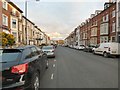
3
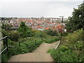
West Cliff from East Cliff
The spire of Whitby Congregational Church and the tower of St. Hilda's church can be seen in the centre of the picture.
Image: © Jonathan Thacker
Taken: 29 Aug 2014
0.02 miles
4
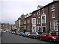
John St, Whitby
The stone building on the right is the Masonic Hall.
Image: © John Lord
Taken: 23 Jun 2011
0.02 miles
6
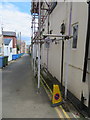
The rear of Clarence Place, Whitby
Looking east along the rear access lane for Clarence Place. There is an Ordnance Survey bench mark on the rear of #6, near the 'no parking' cone - Image
Image: © John S Turner
Taken: 17 Jun 2018
0.04 miles
8
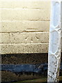
Bench mark on #6 Clarence Place, Whitby
This Ordnance Survey bench mark is on the rear wall of #6 Clarence Place, which was surrounded by scaffolding at the time of this photo - Image
Image: © John S Turner
Taken: 17 Jun 2018
0.04 miles
10
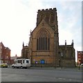
Church of St Hilda
The Grade II* listed https://historicengland.org.uk/listing/the-list/list-entry/1272560 Church of St Hilda was designed by R J Johnson and completed by G E Charnwood 1884-86. The tower was completed in 1938.
Image: © Gerald England
Taken: 14 Dec 2018
0.05 miles