IMAGES TAKEN NEAR TO
Southlands Avenue, WHITBY, YO21 3DY
Introduction
This page details the photographs taken nearby to Southlands Avenue, YO21 3DY by members of the Geograph project.
The Geograph project started in 2005 with the aim of publishing, organising and preserving representative images for every square kilometre of Great Britain, Ireland and the Isle of Man.

There are currently over 7.5m images from over14,400 individuals and you can help contribute to the project by visiting https://www.geograph.org.uk
Image Map
Images are licensed for reuse under creativecommons.org/licenses/by-sa/2.0
Notes
- Clicking on the map will re-center to the selected point.
- The higher the marker number, the further away the image location is from the centre of the postcode.
Image Listing (58 Images Found)
Images are licensed for reuse under creativecommons.org/licenses/by-sa/2.0
Image
Details
Distance
1
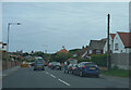
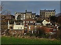
The B1460
The suburbs of Whitby are of a far higher standard than the surrounds of Blackpool.
Image: © Malcolm Neal
Taken: 24 Jul 2021
0.09 miles
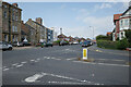
2

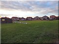
Whitby West Cliff railway station (site), Yorkshire
Opened in 1883 on the North Eastern Railway's line from Redcar to Scarborough, the line continued south from here over the (still extant) Larpool viaduct, high above the Esk valley. There was also a connection from here down into the town station. Trains coming north from Scarborough would have to reverse here to do so. West Cliff station closed in 1961 and most is now gone, but the northbound platform shelter and buildings survive as part of a residential development, and seen here looking north west. The red car is where the tracks would have been.
Image: © Nigel Thompson
Taken: 10 Jun 2011
0.09 miles
3

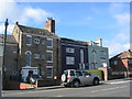
Argyle Road
There is a cut bench mark on the wall to the right of the photograph. A closer view can be seen here: Image
Image: © Mark Anderson
Taken: 12 Jul 2012
0.11 miles
4

Cut Bench Mark, Argyle Road
Bench Mark Database: http://www.bench-marks.org.uk/bm43947
Image: © Mark Anderson
Taken: 12 Jul 2012
0.11 miles
6
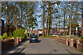
Houses on Upgang Lane
Three grade II listed buildings, all described as late 18th century by Historic England.
Image: © E Gammie
Taken: 13 Sep 2017
0.13 miles
9

Geo. Harrison (Whitby) Ltd., Upgang Lane (A174), Whitby
Image: © habiloid
Taken: 31 Jul 2024
0.16 miles
10
Upgang Lane (A174) and Crescent Avenue, Whitby
Image: © habiloid
Taken: 31 Jul 2024
0.17 miles