IMAGES TAKEN NEAR TO
The Paddock, WHITBY, YO21 3DB
Introduction
This page details the photographs taken nearby to The Paddock, YO21 3DB by members of the Geograph project.
The Geograph project started in 2005 with the aim of publishing, organising and preserving representative images for every square kilometre of Great Britain, Ireland and the Isle of Man.

There are currently over 7.5m images from over14,400 individuals and you can help contribute to the project by visiting https://www.geograph.org.uk
Image Map (Loading...)


Getting Data...Please wait
Leaflet Map data © OpenStreetMap
Images are licensed for reuse under creativecommons.org/licenses/by-sa/2.0
Notes
- Clicking on the map will re-center to the selected point.
- The higher the marker number, the further away the image location is from the centre of the postcode.
Image Listing (2188 Images Found)
Images are licensed for reuse under creativecommons.org/licenses/by-sa/2.0
Image
Details
Distance
1
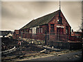
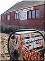
West Cliff Salerooms
Curious brick building where auctions of household objects and artwork are frequently held.
The adjacent plot has been vacant for some time but groundworks are in progress.
Image: © Colin Grice
Taken: 17 Feb 2011
0.01 miles
2
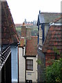
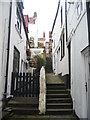
View from The Paddock
The view from the top of the steps down from The Paddock to Cliff Street, with Whitby Abbey ruins in the distance.
Image: © E Gammie
Taken: 10 Sep 2017
0.01 miles
3
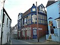
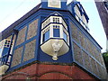
Robert Lennard's house, 10A Cliff Street, Whitby
Lennard was a local architect who designed this distinctive building as his own house and offices. It is dated 1888 and listed grade II (list entry 1239999). For a detail of the oriel window on the corner, see Image
Image: © Stephen Craven
Taken: 3 Sep 2024
0.01 miles
4
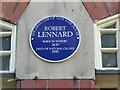
Plaque on Robert Lennard's house
See Image for context.
Image: © Stephen Craven
Taken: 3 Sep 2024
0.01 miles
5
Bay window with ship?s figurehead below it
This is across the corner of a house on the narrow Cliff Street, said to be the house of Robert Lennard who built it as the headquarters of his businesses of architect, builder and antique dealer.
Image: © Eirian Evans
Taken: 15 Sep 2021
0.01 miles
6
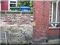
Boundary marker on Cliff Street
Boundary marker between Whitby and Ruswarp parishes between 11 and 10a Cliff Street.
W R
P
W=Whitby to the left, R=Ruswarp to the right
P=Parish
Image: © J G Harston
Taken: 14 May 2016
0.01 miles
7
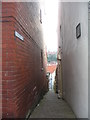
Bakehouse Yard
One of the many narrow alleyways in Whitby, it runs down from Cliff Street to Haggersgate.
The Haggersgate end: Image]
Image: © E Gammie
Taken: 10 Sep 2017
0.02 miles
8
West Cliff Saleroom, Silver Street, Whitby
and the last remnants of the demolished car-sales business next door.
Image: © Richard Allen
Taken: 4 Aug 2008
0.02 miles
9
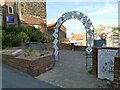
Entrance to the Alice garden, Cliff Street, Whitby
The garden has been created on the site of the former Cliff Street girls' primary school, which opened in 1893 and closed in 1963, but I have not found reference to when it was demolished. Lewis Carroll, the author of the Alice stories, is known to have visited Whitby several times and some people have identified possible local inspiration for some of the scenes.
Image: © Stephen Craven
Taken: 3 Sep 2024
0.02 miles
10
Bakehouse Yard
Looking back up towards Cliff Street from the Haggersgate end.
The Cliff Street end: Image]
Image: © E Gammie
Taken: 15 Sep 2017
0.02 miles