IMAGES TAKEN NEAR TO
Well Close Square, WHITBY, YO21 3AP
Introduction
This page details the photographs taken nearby to Well Close Square, YO21 3AP by members of the Geograph project.
The Geograph project started in 2005 with the aim of publishing, organising and preserving representative images for every square kilometre of Great Britain, Ireland and the Isle of Man.

There are currently over 7.5m images from over14,400 individuals and you can help contribute to the project by visiting https://www.geograph.org.uk
Image Map
Images are licensed for reuse under creativecommons.org/licenses/by-sa/2.0
Notes
- Clicking on the map will re-center to the selected point.
- The higher the marker number, the further away the image location is from the centre of the postcode.
Image Listing (1334 Images Found)
Images are licensed for reuse under creativecommons.org/licenses/by-sa/2.0
Image
Details
Distance
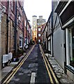
2
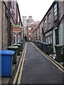
Routh Walk
Narrow dead end street off Skinner Street - bin day!
Image: © Colin Grice
Taken: 17 Feb 2011
0.02 miles
6
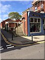
Stone steps off Skinner Street
An imposing sandstone sweep.
Image: © Pauline E
Taken: 2 May 2014
0.04 miles
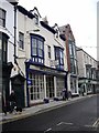
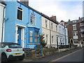
8
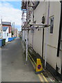
The rear of Clarence Place, Whitby
Looking east along the rear access lane for Clarence Place. There is an Ordnance Survey bench mark on the rear of #6, near the 'no parking' cone - Image
Image: © John S Turner
Taken: 17 Jun 2018
0.05 miles
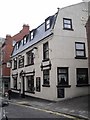
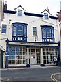
9
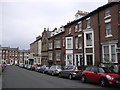
John St, Whitby
The stone building on the right is the Masonic Hall.
Image: © John Lord
Taken: 23 Jun 2011
0.05 miles