IMAGES TAKEN NEAR TO
Carr Lane, WHITBY, YO21 2RA
Introduction
This page details the photographs taken nearby to Carr Lane, YO21 2RA by members of the Geograph project.
The Geograph project started in 2005 with the aim of publishing, organising and preserving representative images for every square kilometre of Great Britain, Ireland and the Isle of Man.

There are currently over 7.5m images from over14,400 individuals and you can help contribute to the project by visiting https://www.geograph.org.uk
Image Map
Images are licensed for reuse under creativecommons.org/licenses/by-sa/2.0
Notes
- Clicking on the map will re-center to the selected point.
- The higher the marker number, the further away the image location is from the centre of the postcode.
Image Listing (66 Images Found)
Images are licensed for reuse under creativecommons.org/licenses/by-sa/2.0
Image
Details
Distance
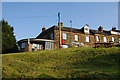
1

Terraced stone houses, Carr End, Glaisdale
Image: © David Smith
Taken: 14 Jun 2015
0.07 miles
2
The Arncliffe Arms, Glaisdale
Viewed from the lane opposite. It was only serving Black Sheep but that was nice enough.
Image: © Bill Boaden
Taken: 4 Sep 2014
0.09 miles
3
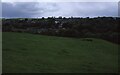
Glaisdale
Glaisdale in Eskdale viewed from Carr Lane, route of Wainwright's Coast to Coast Walk.
Image: © Philip Halling
Taken: 14 Jun 1991
0.10 miles
4
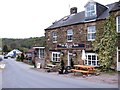
The Arncliffe Arms
Friendly pub with cafe on the lower ground floor. A welcome sight for Coast to Coast walkers who have dropped down from the moor on Glaisdale Rigg.
Image: © Gordon Hatton
Taken: 3 May 2012
0.11 miles
5
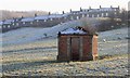
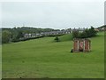
Ruin, Near Glaisdale
This derelict building stands isolated in a field. It is square in plan but of quite an elaborate construction, slate roofed with distinctive brickwork used in the edging and corbelling. It was used as for the storage of blasting powder and is one of the few visible remains of the Glaisdale Ironstone Mine which operated from 1862 to 1874.
The mine was a shaft mine, which has been capped and is located nearby, and ore was taken across a wooden bridge over the River Esk to the ironworks.
In the distance is the houses of Carr End.
Image: © Mick Garratt
Taken: 15 Dec 2007
0.12 miles
6
Ruined blasting powder store, Glaisdale
Built for the Glaisdale ironstone mine, which was active 1862-74. The building has lost its roof since 2007 Image
Image: © Christine Johnstone
Taken: 8 Jun 2019
0.12 miles
7

Lane below Carr End
The row of terraced houses is one of the extremities of Glaisdale village. The lane is signed as being for local traffic only.
Image: © Bill Boaden
Taken: 4 Sep 2014
0.13 miles
8
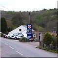
The filling station, Carr End
Village garage and filling station at Carr End, which is the eastern end of Glaisdale village.
Image: © Gordon Hatton
Taken: 3 May 2012
0.15 miles
9

Start of the track to Snowdon Nab
The left fork is a Green Lane which lead from Beggars Bridge to Snowdon Nab.
The lower section is slippery mud and not an easy route in wet weather.
Further up there are deep tractor ruts and it is very narrow.
Image: © Colin Grice
Taken: 3 Aug 2014
0.15 miles
10
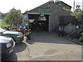
Honey Bee Nest garage
A small garage which sells fuel and does repairs, servicing and MOTs as well as some vehicle sales.
Image: © Colin Grice
Taken: 27 Sep 2011
0.16 miles