IMAGES TAKEN NEAR TO
Danby, WHITBY, YO21 2LN
Introduction
This page details the photographs taken nearby to YO21 2LN by members of the Geograph project.
The Geograph project started in 2005 with the aim of publishing, organising and preserving representative images for every square kilometre of Great Britain, Ireland and the Isle of Man.

There are currently over 7.5m images from over14,400 individuals and you can help contribute to the project by visiting https://www.geograph.org.uk
Image Map
Images are licensed for reuse under creativecommons.org/licenses/by-sa/2.0
Notes
- Clicking on the map will re-center to the selected point.
- The higher the marker number, the further away the image location is from the centre of the postcode.
Image Listing (26 Images Found)
Images are licensed for reuse under creativecommons.org/licenses/by-sa/2.0
Image
Details
Distance
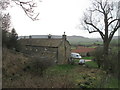

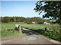
4
Farm on Oakley Side
A footpath runs through the middle of this farm, which is not named on the map.
Park House is to the west. Photo looking east towards Houlsyke.
Image: © Stephen McCulloch
Taken: 11 Sep 2007
0.06 miles
7
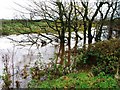
River Esk
The river just dips into this square. Here in flood after a night of heavy rain.
Image: © Mick Garratt
Taken: 25 Nov 2006
0.15 miles
8
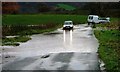
Lawns Road
Overnight rain caused the River Esk to flood. Apparently the depth gauge at Duck Bridge was at 9 foot.
Image: © Mick Garratt
Taken: 25 Nov 2006
0.15 miles