IMAGES TAKEN NEAR TO
Danby, WHITBY, YO21 2LL
Introduction
This page details the photographs taken nearby to YO21 2LL by members of the Geograph project.
The Geograph project started in 2005 with the aim of publishing, organising and preserving representative images for every square kilometre of Great Britain, Ireland and the Isle of Man.

There are currently over 7.5m images from over14,400 individuals and you can help contribute to the project by visiting https://www.geograph.org.uk
Image Map
Images are licensed for reuse under creativecommons.org/licenses/by-sa/2.0
Notes
- Clicking on the map will re-center to the selected point.
- The higher the marker number, the further away the image location is from the centre of the postcode.
Image Listing (6 Images Found)
Images are licensed for reuse under creativecommons.org/licenses/by-sa/2.0
Image
Details
Distance
1
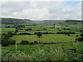
View of Little Fryup Dale
Looking south from the road near Oakley Side House.
Image: © T Eyre
Taken: 25 Jul 2021
0.09 miles
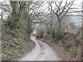
2
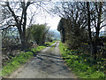
Single track road below Oakley Side
To High Butterwitts Farm.
Image: © Pauline E
Taken: 22 Apr 2015
0.10 miles
3
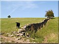
Ever felt you were being watched?
Pasture land at Oakley Side
Image: © Stephen McCulloch
Taken: 11 Sep 2007
0.12 miles
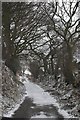
4
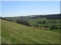
Near Oakley Side house
Looking SE from the bottom of Green Lane.
Image: © T Eyre
Taken: 23 Apr 2021
0.15 miles
6
Minor road above Lawns Road - Esk Valley
This gives access to two or three farms including Oakley Side House and Park House.
Image: © Colin Grice
Taken: 12 Mar 2006
0.21 miles