IMAGES TAKEN NEAR TO
Dibble Bridge Bank, WHITBY, YO21 2BB
Introduction
This page details the photographs taken nearby to Dibble Bridge Bank, YO21 2BB by members of the Geograph project.
The Geograph project started in 2005 with the aim of publishing, organising and preserving representative images for every square kilometre of Great Britain, Ireland and the Isle of Man.

There are currently over 7.5m images from over14,400 individuals and you can help contribute to the project by visiting https://www.geograph.org.uk
Image Map (Loading...)


Getting Data...Please wait
Leaflet Map data © OpenStreetMap
Images are licensed for reuse under creativecommons.org/licenses/by-sa/2.0
Notes
- Clicking on the map will re-center to the selected point.
- The higher the marker number, the further away the image location is from the centre of the postcode.
Image Listing (25 Images Found)
Images are licensed for reuse under creativecommons.org/licenses/by-sa/2.0
Image
Details
Distance
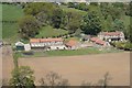
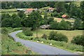
3
Dibble Bridge Farm (view south)
This photograph shows a view of Dibble Bridge Farm from the road that passes by it. The picture was taken looking in a southerly direction towards the River Esk and New Road. The route of the River Esk runs just behind the trees visible in the middle of the picture. The road that runs between Castleton and Westerdale (New Road) can be seen just below the top of the hill in the near horizon and Westerdale Moor can be seen in the distant horizon.
Image: © Philip Barker
Taken: 27 Dec 2009
0.04 miles
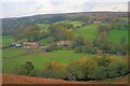
4
The view from Dibble Bridge
Looking towards Maddy Farm.
Image: © Jonathan Thacker
Taken: 15 Oct 2011
0.09 miles
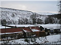
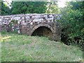
5
Dibble Bridge
Over the River Esk with Dibble Bridge Farm on the far bank.
Image: © Mick Garratt
Taken: 28 Jul 2007
0.10 miles
7
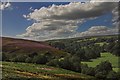
Baysdale meets Eskdale
Baysdale beck meets the young river Esk at this point between Castleton & Westerdale.
Image: © Colin Grice
Taken: 24 Aug 2005
0.11 miles
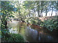
9

The River Esk at Dibble Bridge
Looking downstream.
Image: © Jonathan Thacker
Taken: 15 Oct 2011
0.12 miles
10

Old Boundary Marker northwest of New Road
Parish Boundary Marker On the boundary of Westerdale and Danby parishes (Scarborough District), Dibble Bridge Westerdale, 200 metres NW of New Road.
Surveyed
Milestone Society National ID: YN_WESDAN12pb
Image: © D Garside
Taken: 22 May 2018
0.15 miles