IMAGES TAKEN NEAR TO
Byland Road, WHITBY, YO21 1YF
Introduction
This page details the photographs taken nearby to Byland Road, YO21 1YF by members of the Geograph project.
The Geograph project started in 2005 with the aim of publishing, organising and preserving representative images for every square kilometre of Great Britain, Ireland and the Isle of Man.

There are currently over 7.5m images from over14,400 individuals and you can help contribute to the project by visiting https://www.geograph.org.uk
Image Map (Loading...)


Getting Data...Please wait
Leaflet Map data © OpenStreetMap
Images are licensed for reuse under creativecommons.org/licenses/by-sa/2.0
Notes
- Clicking on the map will re-center to the selected point.
- The higher the marker number, the further away the image location is from the centre of the postcode.
Image Listing (19 Images Found)
Images are licensed for reuse under creativecommons.org/licenses/by-sa/2.0
Image
Details
Distance
1

Stakesby Manor View
The view from Stakesby Manor Hotel across to Whitby and the abbey on the cliff top. I understand the hotel has since been converted into apartments.
Image: © Gerald England
Taken: 28 Jun 1978
0.08 miles
2

Bridge over Stakesby Vale Beck
This photograph shows a view of the footbridge that carries the public footpath (from the B1416 road) over Stakesby Vale Beck. Some of the houses in the High Stakesby area of Whitby can just be seen in the background. The picture was taken looking in a northerly direction towards Whitby Sands.
Image: © Philip Barker
Taken: 25 Mar 2010
0.11 miles
3
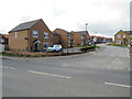
Convent Way, Whitby
Convent Way forms part of a newly-built housing development in Whitby.
Image: © Malc McDonald
Taken: 29 Apr 2021
0.13 miles

6
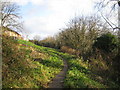
Stakesby Vale
Footpath through Stakesby Vale looking back towards Whitby. Stream on the right. Housing estate on the left.
Image: © John Winterbottom
Taken: 16 Dec 2005
0.17 miles
7
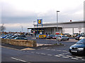
Lidl supermarket on Stakesby Road
Opposite Stakesby Garage
Image: © Stephen McCulloch
Taken: 11 Mar 2008
0.19 miles
8
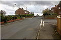
The Junction of Castle Road and Stakesby Road
At the junction of Castle Road (B1460) and Stakesby Road (B1416) to the west of Whitby.
The construction work is for The Mayfield Care Home replacing what I think were farm buildings.
Image: © Jeff Buck
Taken: 27 Jun 2022
0.20 miles
9

Old Milepost
Old milepost on what was the A.171 at Whitby, North Yorkshire. For close up view see http://www.geograph.org.uk/photo/1904112
Image: © Keith Evans
Taken: 2 Jun 2010
0.20 miles
10
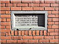
Tablet on house wall in Whitby
This tablet is incorporated in the brickwork of a modern terraced house in Whitby and marks the spot where a shell from a German battlecruiser landed during the raid of December 16th 1914. A German naval force had arrived off the east coast and whilst the northern group attacked Hartlepool, which had British naval facilities, two battlecruisers, the Derfflinger and the Van der Tann attacked both Whitby and Scarborough, two undefended towns. The Whitby raid was at around 9am and lasted for just 10 minutes, causing the death of 3 people. The raids caused public outrage in Britain, due largely to the fact that the German ships had attacked undefended towns of no military significance.
Image: © Gordon Hatton
Taken: 6 Nov 2017
0.21 miles