IMAGES TAKEN NEAR TO
Carr Hill Ridge, WHITBY, YO21 1RZ
Introduction
This page details the photographs taken nearby to Carr Hill Ridge, YO21 1RZ by members of the Geograph project.
The Geograph project started in 2005 with the aim of publishing, organising and preserving representative images for every square kilometre of Great Britain, Ireland and the Isle of Man.

There are currently over 7.5m images from over14,400 individuals and you can help contribute to the project by visiting https://www.geograph.org.uk
Image Map
Images are licensed for reuse under creativecommons.org/licenses/by-sa/2.0
Notes
- Clicking on the map will re-center to the selected point.
- The higher the marker number, the further away the image location is from the centre of the postcode.
Image Listing (3 Images Found)
Images are licensed for reuse under creativecommons.org/licenses/by-sa/2.0
Image
Details
Distance
1
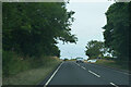
The A169
The road the A169 is somewhat variable in the density of traffic, sometimes quite empty at others quite crowded.
Image: © Malcolm Neal
Taken: 24 Jul 2021
0.08 miles
2
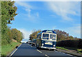
Royal Blue to Kathmandu
VDV 749, seen here on the A169 heading down to Sleights, is the last remaining LS Bristol from the Swagman fleet. Swagman ran overland camping tours to North Africa and India. During the Arab/Israeli war, Nepal replaced Bombay as the final destination.
Currently in service with Coastal and Country Coaches Ltd, Whitby.
Image: © Pauline E
Taken: 23 Oct 2013
0.08 miles
3
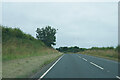
An empty A169
The heat of the previous week has dried out the grass verges, which are looking quite pale.
Image: © Malcolm Neal
Taken: 24 Jul 2021
0.19 miles