IMAGES TAKEN NEAR TO
Waterstead Lane, WHITBY, YO21 1PX
Introduction
This page details the photographs taken nearby to Waterstead Lane, YO21 1PX by members of the Geograph project.
The Geograph project started in 2005 with the aim of publishing, organising and preserving representative images for every square kilometre of Great Britain, Ireland and the Isle of Man.

There are currently over 7.5m images from over14,400 individuals and you can help contribute to the project by visiting https://www.geograph.org.uk
Image Map (Loading...)


Getting Data...Please wait
Leaflet Map data © OpenStreetMap
Images are licensed for reuse under creativecommons.org/licenses/by-sa/2.0
Notes
- Clicking on the map will re-center to the selected point.
- The higher the marker number, the further away the image location is from the centre of the postcode.
Image Listing (124 Images Found)
Images are licensed for reuse under creativecommons.org/licenses/by-sa/2.0
Image
Details
Distance
1
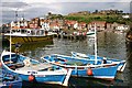
Whitby harbour from new Quay
Colourful scene of Whitby's busy harbour.
Image: © Graham Proud
Taken: 2 Jul 2004
0.06 miles
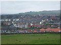
3

Whitby
Standing in the grounds of Whitby Abbey looking down on the town.
Image: © danny
Taken: 13 Apr 2008
0.10 miles
4
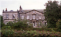
Airy Hill, Whitby
Built in 1790 for Richard Moorson, local shipowner and magistrate (part of the house was apparently used as a court). The porch is later. Grade II* listed.
It appears to have converted into flats.
Image: © Stephen Richards
Taken: 18 Aug 2002
0.10 miles


8
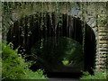
A171 Prospect Hill bridge, Whitby
Crossing the Cinder Track.
Image: © Mat Fascione
Taken: 10 Aug 2018
0.12 miles