IMAGES TAKEN NEAR TO
Holly Tree Court, WHITBY, YO21 1JQ
Introduction
This page details the photographs taken nearby to Holly Tree Court, YO21 1JQ by members of the Geograph project.
The Geograph project started in 2005 with the aim of publishing, organising and preserving representative images for every square kilometre of Great Britain, Ireland and the Isle of Man.

There are currently over 7.5m images from over14,400 individuals and you can help contribute to the project by visiting https://www.geograph.org.uk
Image Map
Images are licensed for reuse under creativecommons.org/licenses/by-sa/2.0
Notes
- Clicking on the map will re-center to the selected point.
- The higher the marker number, the further away the image location is from the centre of the postcode.
Image Listing (10 Images Found)
Images are licensed for reuse under creativecommons.org/licenses/by-sa/2.0
Image
Details
Distance
1
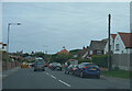
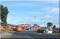
The B1460
The suburbs of Whitby are of a far higher standard than the surrounds of Blackpool.
Image: © Malcolm Neal
Taken: 24 Jul 2021
0.07 miles

5

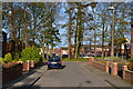
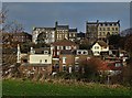
Whitby West Cliff railway station (site), Yorkshire
Opened in 1883 on the North Eastern Railway's line from Redcar to Scarborough, the line continued south from here over the (still extant) Larpool viaduct, high above the Esk valley. There was also a connection from here down into the town station. Trains coming north from Scarborough would have to reverse here to do so. West Cliff station closed in 1961 and most is now gone, but the northbound platform shelter and buildings survive as part of a residential development, and seen here looking north west. The red car is where the tracks would have been.
Image: © Nigel Thompson
Taken: 10 Jun 2011
0.15 miles
6
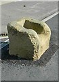
Old Wayside Cross by the B1460, Stakesby Road, Whitby
Wishing Chair Cross, old base by the B1460, in parish of Whitby (Scarborough District), Stakesby Road, between junction with Love Lane and Westbourne Road (opposite The new Sanctuary Cross made for the Festival of Britain), by supermarket, in pavement (a mile from Whitby Abbey).
Scheduled Monument.
List Entry Number: 1009851 https://historicengland.org.uk/listing/the-list/list-entry/1009851
Surveyed
Milestone Society National ID: YNSC_WHI03
Image: © Milestone Society
Taken: Unknown
0.23 miles
8
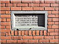
Tablet on house wall in Whitby
This tablet is incorporated in the brickwork of a modern terraced house in Whitby and marks the spot where a shell from a German battlecruiser landed during the raid of December 16th 1914. A German naval force had arrived off the east coast and whilst the northern group attacked Hartlepool, which had British naval facilities, two battlecruisers, the Derfflinger and the Van der Tann attacked both Whitby and Scarborough, two undefended towns. The Whitby raid was at around 9am and lasted for just 10 minutes, causing the death of 3 people. The raids caused public outrage in Britain, due largely to the fact that the German ships had attacked undefended towns of no military significance.
Image: © Gordon Hatton
Taken: 6 Nov 2017
0.23 miles
9
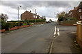
Love Lane running down to Castle Road
Image: © Steve Daniels
Taken: 18 May 2016
0.24 miles
10
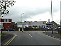
Spar petrol station and Lidl entrance
Castle Road, heading into Whitby.
Image: © Pauline E
Taken: 9 Oct 2013
0.25 miles