IMAGES TAKEN NEAR TO
Kirkham Road, WHITBY, YO21 1HE
Introduction
This page details the photographs taken nearby to Kirkham Road, YO21 1HE by members of the Geograph project.
The Geograph project started in 2005 with the aim of publishing, organising and preserving representative images for every square kilometre of Great Britain, Ireland and the Isle of Man.

There are currently over 7.5m images from over14,400 individuals and you can help contribute to the project by visiting https://www.geograph.org.uk
Image Map
Images are licensed for reuse under creativecommons.org/licenses/by-sa/2.0
Notes
- Clicking on the map will re-center to the selected point.
- The higher the marker number, the further away the image location is from the centre of the postcode.
Image Listing (157 Images Found)
Images are licensed for reuse under creativecommons.org/licenses/by-sa/2.0
Image
Details
Distance

3
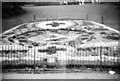
The Floral Clock in Pannett Park
The Floral Clock in Pannett Park was originally installed in 1953 to commemorate the coronation of Queen Elizabeth II on June 2nd 1953.
Pannett Park website https://www.pannettpark.co.uk/about-the-park/history-of-pannett-park/the-floral-clock/
Image: © Jeff Buck
Taken: 27 Jun 2022
0.06 miles
4
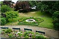
The Cinder Track bridge
Crossing Southend Gardens in Whitby.
Image: © Mat Fascione
Taken: 10 Aug 2018
0.06 miles

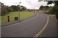
6
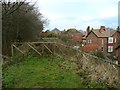
The end of the railway path at Whitby
There is an unfortunate gap in the route here. The old railway track seems to have been added to the grounds of a house, beyond which it has become a residential road (Kirkham Road).
Image: © Humphrey Bolton
Taken: 25 Dec 2012
0.07 miles
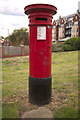
8
Rievaulx Road, Whitby
A closer view of the postbox can be seen here: Image
Image: © Mark Anderson
Taken: 4 Jun 2017
0.07 miles
9
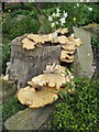
Bracket fungus
Spotted in Pannett Park, this large bracket fungus had made itself at home on this tree stump.
Image: © Mike Kirby
Taken: 16 Jun 2014
0.07 miles
10
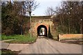
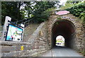
Tunnel under disused railway
This photograph shows a view of a tunnel underneath the (now disused) railway line which used to run between Scarborough (in the south) and Staithes (in the north). The section of track that lies to the right of the tunnel is now used as a walkway (see here: Image ); a flight of steps on the other side of the tunnel provides access to this. The picture was taken looking in an east-north-easterly direction towards Fishburn Park.
Image: © Philip Barker
Taken: 25 Mar 2010
0.07 miles