IMAGES TAKEN NEAR TO
Harrowing Drive, WHITBY, YO21 1AD
Introduction
This page details the photographs taken nearby to Harrowing Drive, YO21 1AD by members of the Geograph project.
The Geograph project started in 2005 with the aim of publishing, organising and preserving representative images for every square kilometre of Great Britain, Ireland and the Isle of Man.

There are currently over 7.5m images from over14,400 individuals and you can help contribute to the project by visiting https://www.geograph.org.uk
Image Map
Images are licensed for reuse under creativecommons.org/licenses/by-sa/2.0
Notes
- Clicking on the map will re-center to the selected point.
- The higher the marker number, the further away the image location is from the centre of the postcode.
Image Listing (75 Images Found)
Images are licensed for reuse under creativecommons.org/licenses/by-sa/2.0
Image
Details
Distance
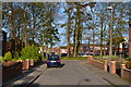
3
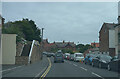
The B1460
The suburbs of Whitby are of a far higher standard than the surrounds of Blackpool.
Image: © Malcolm Neal
Taken: 24 Jul 2021
0.13 miles


6
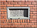
Tablet on house wall in Whitby
This tablet is incorporated in the brickwork of a modern terraced house in Whitby and marks the spot where a shell from a German battlecruiser landed during the raid of December 16th 1914. A German naval force had arrived off the east coast and whilst the northern group attacked Hartlepool, which had British naval facilities, two battlecruisers, the Derfflinger and the Van der Tann attacked both Whitby and Scarborough, two undefended towns. The Whitby raid was at around 9am and lasted for just 10 minutes, causing the death of 3 people. The raids caused public outrage in Britain, due largely to the fact that the German ships had attacked undefended towns of no military significance.
Image: © Gordon Hatton
Taken: 6 Nov 2017
0.15 miles
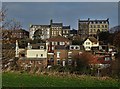
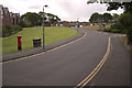
7
Looks like parking will be a problem
With the road lined with parked cars even before we reach the seafront area I guess parking will be a problem.
Image: © Malcolm Neal
Taken: 24 Jul 2021
0.16 miles
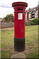
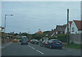
9
Rievaulx Road, Whitby
A closer view of the postbox can be seen here: Image
Image: © Mark Anderson
Taken: 4 Jun 2017
0.17 miles
10
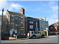
Houses on Upgang Lane
Three grade II listed buildings, all described as late 18th century by Historic England.
Image: © E Gammie
Taken: 13 Sep 2017
0.18 miles