IMAGES TAKEN NEAR TO
Percys Lane, YORK, YO1 9RS
Introduction
This page details the photographs taken nearby to Percys Lane, YO1 9RS by members of the Geograph project.
The Geograph project started in 2005 with the aim of publishing, organising and preserving representative images for every square kilometre of Great Britain, Ireland and the Isle of Man.

There are currently over 7.5m images from over14,400 individuals and you can help contribute to the project by visiting https://www.geograph.org.uk
Image Map
Images are licensed for reuse under creativecommons.org/licenses/by-sa/2.0
Notes
- Clicking on the map will re-center to the selected point.
- The higher the marker number, the further away the image location is from the centre of the postcode.
Image Listing (737 Images Found)
Images are licensed for reuse under creativecommons.org/licenses/by-sa/2.0
Image
Details
Distance
2
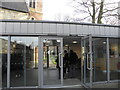
National Centre for Early Music
The modern entrance to the restored church used as a musical practice and performance centre.
Image: © Michael Steele
Taken: 7 Apr 2010
0.02 miles
3
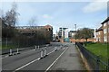
Apartment blocks
At the junction of Navigation Road and Rosemary Place.
Image: © Andrew Abbott
Taken: 24 Aug 2019
0.02 miles
4
Rosemary Place
Looking across Navigation Road into Rosemary Place. This area of York was extensively flooded following the boxing day rainfall and subsequent river level rises. Normally this area wouldn't flood as it is protected by the Foss Barrier, which failed this time. The water level marks can be seen on the property on the left. A car transporter was collecting cars next to where I was stood.
Image: © DS Pugh
Taken: 1 Jan 2016
0.02 miles
5
Cycle lanes on Navigation Road
This section of Navigation Road is one way to motor vehicles and bidirectional for bicycles.
Image: © DS Pugh
Taken: 19 Mar 2023
0.02 miles
6
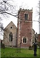
St Margaret's church
The church is largely 14th century with a brick built tower of 1685. The church, like several others within York's city walls became redundant, but has now found a new life as the National Centre for Early Music, and concerts are regularly performed here.
Image: © Gordon Hatton
Taken: 3 Feb 2008
0.03 miles
7
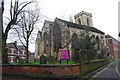
St Denys Church, Walmgate
Built on the site of a Saxon church and possibly a Roman temple, this small mediaeval church was first recorded in c.1154. One of only about 40 English churches dedicated to St Denys, whose figure can be seen in the 15th century east window.
Image: © hayley green
Taken: 6 Feb 2010
0.03 miles
8

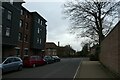
Navigation Road
The footpath to Hungate Bridge is on the left as the road bends to the right.
Image: © DS Pugh
Taken: 26 Aug 2022
0.04 miles
9
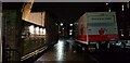
Percy's Lane
Looking towards Navigation Road.
Image: © DS Pugh
Taken: 19 Mar 2021
0.05 miles
10
Percy's Lane
Looking along the outside of the National Centre for Early Music which has a blood donor session in progress.
Image: © DS Pugh
Taken: 28 Feb 2022
0.05 miles