IMAGES TAKEN NEAR TO
Skipwith Road, YORK, YO19 6EJ
Introduction
This page details the photographs taken nearby to Skipwith Road, YO19 6EJ by members of the Geograph project.
The Geograph project started in 2005 with the aim of publishing, organising and preserving representative images for every square kilometre of Great Britain, Ireland and the Isle of Man.

There are currently over 7.5m images from over14,400 individuals and you can help contribute to the project by visiting https://www.geograph.org.uk
Image Map
Images are licensed for reuse under creativecommons.org/licenses/by-sa/2.0
Notes
- Clicking on the map will re-center to the selected point.
- The higher the marker number, the further away the image location is from the centre of the postcode.
Image Listing (9 Images Found)
Images are licensed for reuse under creativecommons.org/licenses/by-sa/2.0
Image
Details
Distance
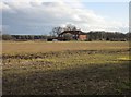
1
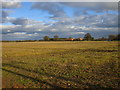
Stubble field and Whinchat Hall
Whinchat Hall is one of the subsidiary farms of the Escrick Estate.
Image: © Jonathan Thacker
Taken: 16 Mar 2017
0.03 miles
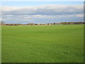
3
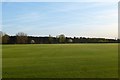
Fields of lawn turf
Lots of fields round here are growing turf for sale.
Image: © DS Pugh
Taken: 4 May 2016
0.17 miles
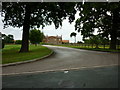
4
Whinchat Cottages
Seen from Potter's Lane.
Image: © Jonathan Thacker
Taken: 16 Mar 2017
0.18 miles
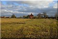
5
Whinchat Cottages
Look quite isolated but the road which passes by can get quite busy at times being used as a rat-run from York to the A163 avoiding the A19.
Image: © Jonathan Thacker
Taken: 16 Mar 2017
0.18 miles
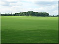
6
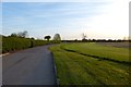
View towards Roth Hill
The grass in the foreground is being grown for turves. In the distance can be seen the plant of Hartleys who are important vegetable growers and suppliers.
Image: © Jonathan Thacker
Taken: 16 Mar 2017
0.19 miles
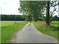
9
Drive to Menagerie Farm
Leading through to the business park on the Escrick Park Estate.
Image: © DS Pugh
Taken: 4 May 2016
0.23 miles