IMAGES TAKEN NEAR TO
Skipwith Road, YORK, YO19 6EG
Introduction
This page details the photographs taken nearby to Skipwith Road, YO19 6EG by members of the Geograph project.
The Geograph project started in 2005 with the aim of publishing, organising and preserving representative images for every square kilometre of Great Britain, Ireland and the Isle of Man.

There are currently over 7.5m images from over14,400 individuals and you can help contribute to the project by visiting https://www.geograph.org.uk
Image Map
Images are licensed for reuse under creativecommons.org/licenses/by-sa/2.0
Notes
- Clicking on the map will re-center to the selected point.
- The higher the marker number, the further away the image location is from the centre of the postcode.
Image Listing (12 Images Found)
Images are licensed for reuse under creativecommons.org/licenses/by-sa/2.0
Image
Details
Distance
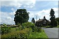
1

Wheldrake Lane
Looking along Wheldrake Lane with the school behind.
Image: © DS Pugh
Taken: 2 Feb 2003
0.00 miles
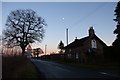
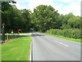
2
East Lodge
The corner of Wheldrake Lane and Mill Hill.
Image: © DS Pugh
Taken: 7 Aug 2021
0.00 miles
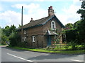
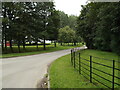
3
House on Wheldrake Lane
At the junction with Mill Hill near Escrick.
Image: © DS Pugh
Taken: 11 Jan 2014
0.01 miles
8
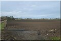
Hedgerow north of Wheldrake Lane
Looking across farmland which is part of the Escrick Park estate.
Image: © DS Pugh
Taken: 8 Jan 2023
0.13 miles
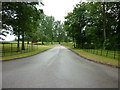
9
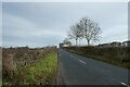
Wheldrake Lane near Skipwith Road
Looking along the lane leading to Wheldrake from Escrick.
Image: © DS Pugh
Taken: 8 Jan 2023
0.15 miles
10
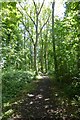
Gashouse Plantation
A small area of woodland belonging to the Escrick Park Estate.
Image: © DS Pugh
Taken: 24 Aug 2014
0.15 miles