IMAGES TAKEN NEAR TO
Holtby Lane, YORK, YO19 5XQ
Introduction
This page details the photographs taken nearby to Holtby Lane, YO19 5XQ by members of the Geograph project.
The Geograph project started in 2005 with the aim of publishing, organising and preserving representative images for every square kilometre of Great Britain, Ireland and the Isle of Man.

There are currently over 7.5m images from over14,400 individuals and you can help contribute to the project by visiting https://www.geograph.org.uk
Image Map
Images are licensed for reuse under creativecommons.org/licenses/by-sa/2.0
Notes
- Clicking on the map will re-center to the selected point.
- The higher the marker number, the further away the image location is from the centre of the postcode.
Image Listing (22 Images Found)
Images are licensed for reuse under creativecommons.org/licenses/by-sa/2.0
Image
Details
Distance
2
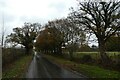
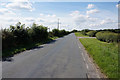
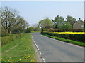
Rudcarr Lane
Looking along Rudcarr Lane leading to Warthill near the junction with Holtby Lane.
Image: © DS Pugh
Taken: 14 Nov 2020
0.08 miles
3
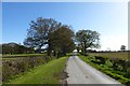
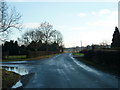
Rudcarr Lane
Looking towards its junction with Holtby Lane.
Image: © DS Pugh
Taken: 2 May 2016
0.09 miles
4
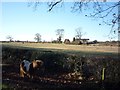
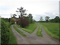
Shetland on Rudcarr Lane
Looking towards Primrose Farm.
Image: © DS Pugh
Taken: 2 Dec 2012
0.10 miles
5
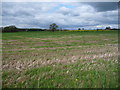
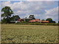
Rudcarrs farmland, drained by Carr Goit
About 18 metres above sea level.
Image: © Christine Johnstone
Taken: 29 Apr 2018
0.14 miles
7
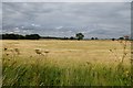
Farmland off Holtby Lane
Looking across a field of Barley.
Image: © DS Pugh
Taken: 28 Jul 2013
0.15 miles