IMAGES TAKEN NEAR TO
Osbaldwick Industrial Estate, Outgang Lane, YORK, YO19 5UX
Introduction
This page details the photographs taken nearby to Osbaldwick Industrial Estate, Outgang Lane, YO19 5UX by members of the Geograph project.
The Geograph project started in 2005 with the aim of publishing, organising and preserving representative images for every square kilometre of Great Britain, Ireland and the Isle of Man.

There are currently over 7.5m images from over14,400 individuals and you can help contribute to the project by visiting https://www.geograph.org.uk
Image Map (Loading...)


Getting Data...Please wait
Leaflet Map data © OpenStreetMap
Images are licensed for reuse under creativecommons.org/licenses/by-sa/2.0
Notes
- Clicking on the map will re-center to the selected point.
- The higher the marker number, the further away the image location is from the centre of the postcode.
Image Listing (43 Images Found)
Images are licensed for reuse under creativecommons.org/licenses/by-sa/2.0
Image
Details
Distance
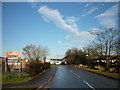
1

Industrial Units on Outgangs Lane
Looking toward Murton Way
Image: © Martin Dawes
Taken: 23 Feb 2015
0.04 miles
2

Transmission lines near Osbaldwick
Two electric pylons in farmland near Osbaldwick.
Image: © DS Pugh
Taken: 5 May 2020
0.04 miles
4

Field near Osbaldwick
Looking across a field from a footpath near to Osbaldwick.
Image: © DS Pugh
Taken: 5 May 2020
0.07 miles
5
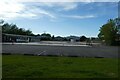
Demolished buildings
Looking across part of the Osbaldwick industrial estate. This was formally the DVSA test centre.
Image: © DS Pugh
Taken: 19 May 2022
0.07 miles
7

Footpath near Outgang Lane
Looking across a footpath leading from Osbaldwick.
Image: © DS Pugh
Taken: 5 May 2020
0.09 miles
9

Osbaldwick railway station (site), Yorkshire
Opened in 1913 by the Derwent Valley Light Railway on the line from York (Layerthorpe) to Cliffe Common, this station closed to passengers in 1926 and completely in 1981.
View east towards Murton Lane and Cliffe Common. The site has been redeveloped and no trace apparently remains.
Image: © Nigel Thompson
Taken: 27 Apr 2019
0.10 miles
10
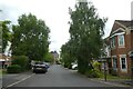
Beckett Drive
Looking along a street of fairly recent housing in Osbaldwick.
Image: © DS Pugh
Taken: 12 Jun 2022
0.13 miles