IMAGES TAKEN NEAR TO
Stamford Bridge Road, YORK, YO19 5AE
Introduction
This page details the photographs taken nearby to Stamford Bridge Road, YO19 5AE by members of the Geograph project.
The Geograph project started in 2005 with the aim of publishing, organising and preserving representative images for every square kilometre of Great Britain, Ireland and the Isle of Man.

There are currently over 7.5m images from over14,400 individuals and you can help contribute to the project by visiting https://www.geograph.org.uk
Image Map (Loading...)


Getting Data...Please wait
Leaflet Map data © OpenStreetMap
Images are licensed for reuse under creativecommons.org/licenses/by-sa/2.0
Notes
- Clicking on the map will re-center to the selected point.
- The higher the marker number, the further away the image location is from the centre of the postcode.
Image Listing (12 Images Found)
Images are licensed for reuse under creativecommons.org/licenses/by-sa/2.0
Image
Details
Distance
2
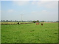
Horses at Providence Farm
Taken from Back Lane, Holtby.
Image: © DS Pugh
Taken: 17 Sep 2006
0.11 miles
3
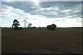
Field beside Back Lane
With a wind turbine ahead.
Image: © DS Pugh
Taken: 15 May 2020
0.14 miles
4
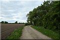
Back Lane
Looking along Back Lane which runs to Holtby.
Image: © DS Pugh
Taken: 15 May 2020
0.16 miles
5
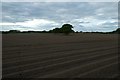
Prepared field off Back Lane
Looking across farmland near Holtby.
Image: © DS Pugh
Taken: 15 May 2020
0.16 miles
6
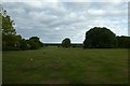
Golf tees at Dunnington Hall
With rather oversized balls for golf.
Image: © DS Pugh
Taken: 15 May 2020
0.18 miles
7
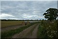
Bales beside Back Lane
Looking along Back Lane leading to Holtby.
Image: © DS Pugh
Taken: 15 May 2020
0.21 miles
8

Farmland near Dunnington
Taken from the junction of the bridlepath with Eastfield Lane.
Image: © DS Pugh
Taken: 11 Sep 2005
0.22 miles
9

Clear March day looking down Petercroft Lane
A late fall of snow in the winter of 2006 highlights the effect it can have on the village landscape
Image: © robin robson
Taken: 1 Jan 2006
0.22 miles
10

Bridleway to Eastfield Lane
Looking along a bridleway leading between the A166 and Eastfield Lane.
Image: © DS Pugh
Taken: 15 May 2020
0.23 miles