IMAGES TAKEN NEAR TO
Crockey Hill, YORK, YO19 4SR
Introduction
This page details the photographs taken nearby to YO19 4SR by members of the Geograph project.
The Geograph project started in 2005 with the aim of publishing, organising and preserving representative images for every square kilometre of Great Britain, Ireland and the Isle of Man.

There are currently over 7.5m images from over14,400 individuals and you can help contribute to the project by visiting https://www.geograph.org.uk
Image Map
Images are licensed for reuse under creativecommons.org/licenses/by-sa/2.0
Notes
- Clicking on the map will re-center to the selected point.
- The higher the marker number, the further away the image location is from the centre of the postcode.
Image Listing (4 Images Found)
Images are licensed for reuse under creativecommons.org/licenses/by-sa/2.0
Image
Details
Distance
1
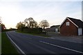
A19 between Deighton and Crockey Hill
The main Selby to York road.
Image: © DS Pugh
Taken: 4 May 2016
0.03 miles
2
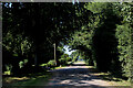
On the Eastern End of Howden Lane
Heading west along a narrow lane through a green tunnel
Image: © Chris Heaton
Taken: 26 Jul 2021
0.22 miles
3
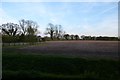
Farmland south of Howden Lane
Close to the A19 junction.
Image: © DS Pugh
Taken: 4 May 2016
0.23 miles
4
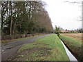
Howden Lane
Looking in the direction of the A19.
Image: © Jonathan Thacker
Taken: 30 Dec 2017
0.24 miles