IMAGES TAKEN NEAR TO
Howden Lane, YORK, YO19 4RP
Introduction
This page details the photographs taken nearby to Howden Lane, YO19 4RP by members of the Geograph project.
The Geograph project started in 2005 with the aim of publishing, organising and preserving representative images for every square kilometre of Great Britain, Ireland and the Isle of Man.

There are currently over 7.5m images from over14,400 individuals and you can help contribute to the project by visiting https://www.geograph.org.uk
Image Map
Images are licensed for reuse under creativecommons.org/licenses/by-sa/2.0
Notes
- Clicking on the map will re-center to the selected point.
- The higher the marker number, the further away the image location is from the centre of the postcode.
Image Listing (33 Images Found)
Images are licensed for reuse under creativecommons.org/licenses/by-sa/2.0
Image
Details
Distance
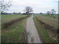
1
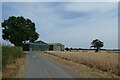
Farm buildings along Howden Lane
Looking along Howden Lane to the east of the York-Selby cycle path.
Image: © DS Pugh
Taken: 17 Jul 2022
0.05 miles
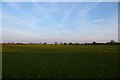
3
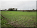
Autumn sown crops off Howden Lane near Naburn
Image: © Jonathan Thacker
Taken: 30 Dec 2017
0.08 miles
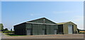
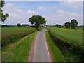
6
Farmland off Howden Lane
Looking north from Howden Lane at arable crops growing.
Image: © DS Pugh
Taken: 4 May 2016
0.15 miles
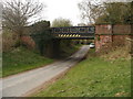
7
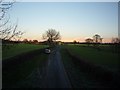
Howden Lane
Looking down from the bridge carrying the trackbed of the old east coast main line between York and Selby.
Image: © DS Pugh
Taken: 18 Dec 2011
0.15 miles

9
Howden Lane
Taken from the Howden Lane bridge.
Image: © Sam Kelly
Taken: 29 May 2008
0.16 miles
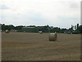
10
Howden Lane Bridge
Howden Lane Bridge where there is access to the 15 mile long Selby & York Railway Path.
Image: © SMJ
Taken: 6 Apr 2009
0.18 miles