IMAGES TAKEN NEAR TO
Newton-on-Rawcliffe, PICKERING, YO18 8QQ
Introduction
This page details the photographs taken nearby to YO18 8QQ by members of the Geograph project.
The Geograph project started in 2005 with the aim of publishing, organising and preserving representative images for every square kilometre of Great Britain, Ireland and the Isle of Man.

There are currently over 7.5m images from over14,400 individuals and you can help contribute to the project by visiting https://www.geograph.org.uk
Image Map
Images are licensed for reuse under creativecommons.org/licenses/by-sa/2.0
Notes
- Clicking on the map will re-center to the selected point.
- The higher the marker number, the further away the image location is from the centre of the postcode.
Image Listing (15 Images Found)
Images are licensed for reuse under creativecommons.org/licenses/by-sa/2.0
Image
Details
Distance
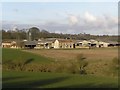
1
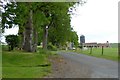
Access road to Saintoft Grange
Image: © David Smith
Taken: 19 Jun 2015
0.02 miles
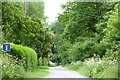
2
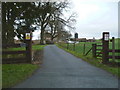
Driveway to Saintoft Grange
Also a waymarked public footpath.
Image: © Phil Catterall
Taken: 30 Dec 2007
0.03 miles
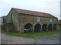
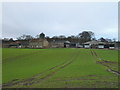
6
Saintoft Grange
Large scale farm near the edge of the Cropton Forest and Cawthorn Roman Camp.
Image: © Colin Grice
Taken: 19 Feb 2006
0.09 miles
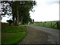
8
Bradley Road, a cul-de-sac off Low Moor Road
This wooded track leads to a few scattered houses, and continues with footpaths and tracks on Haugh Rigg
Image: © David Smith
Taken: 19 Jun 2015
0.14 miles
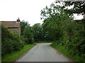
9
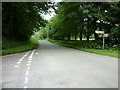
The junction of Low Moor Road and Swainsea Lane
Image: © Ian S
Taken: 10 Jul 2011
0.14 miles
10
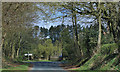
North end of Swainsea Lane
Right to Stape and left to Cawthorne.
Image: © Pauline E
Taken: 22 Apr 2015
0.14 miles