IMAGES TAKEN NEAR TO
Swainsea Lane, PICKERING, YO18 8PW
Introduction
This page details the photographs taken nearby to Swainsea Lane, YO18 8PW by members of the Geograph project.
The Geograph project started in 2005 with the aim of publishing, organising and preserving representative images for every square kilometre of Great Britain, Ireland and the Isle of Man.

There are currently over 7.5m images from over14,400 individuals and you can help contribute to the project by visiting https://www.geograph.org.uk
Image Map
Images are licensed for reuse under creativecommons.org/licenses/by-sa/2.0
Notes
- Clicking on the map will re-center to the selected point.
- The higher the marker number, the further away the image location is from the centre of the postcode.
Image Listing (9 Images Found)
Images are licensed for reuse under creativecommons.org/licenses/by-sa/2.0
Image
Details
Distance
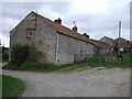
2
Farm track (footpath) towards Swainsea Lane
Image: © JThomas
Taken: 10 Sep 2012
0.07 miles
4
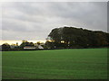
Woodland by Nova Lodge, seen from Swainsea Lane
Image: © David Smith
Taken: 19 Jun 2015
0.16 miles
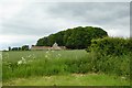
5
Woodland and Nova Lodge
The trees tower over Nova Lodge in itself a quite substantial house with attractive farm buildings.
Image: © Jonathan Thacker
Taken: 14 Oct 2017
0.16 miles
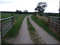
6
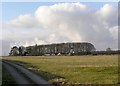
Nova Lodge
The track leads to The Broates, the farm by the sheltering trees is Nova Lodge accessed by a lane a few metres further North along Swainsea Lane.
Image: © Colin Grice
Taken: 19 Feb 2006
0.17 miles
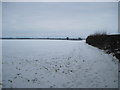
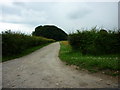
7

Near The Broates
Looking south across the Vale of Pickering near The Broates.
Image: © T Eyre
Taken: 14 Apr 2021
0.20 miles
9
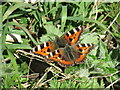
Small Tortoiseshells
Two Small Tortoiseshells near The Broats.
Image: © T Eyre
Taken: 14 Apr 2021
0.23 miles