IMAGES TAKEN NEAR TO
Stape, PICKERING, YO18 8HZ
Introduction
This page details the photographs taken nearby to YO18 8HZ by members of the Geograph project.
The Geograph project started in 2005 with the aim of publishing, organising and preserving representative images for every square kilometre of Great Britain, Ireland and the Isle of Man.

There are currently over 7.5m images from over14,400 individuals and you can help contribute to the project by visiting https://www.geograph.org.uk
Image Map
Images are licensed for reuse under creativecommons.org/licenses/by-sa/2.0
Notes
- Clicking on the map will re-center to the selected point.
- The higher the marker number, the further away the image location is from the centre of the postcode.
Image Listing (13 Images Found)
Images are licensed for reuse under creativecommons.org/licenses/by-sa/2.0
Image
Details
Distance
1
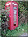
Unloved phone box
Though still apparently in working order it would now be quite difficult to actually get into it.
Surprisingly Stape has a reasonable mobile cover perhaps partly due to being within sight of the busy A169 Pickering to Whitby Road.
Image: © Colin Grice
Taken: 7 Sep 2014
0.05 miles
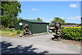
4
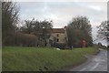
Stape Head Farm
Someone here is accomplished at carving large wooden sculptures, presumably using mainly a chainsaw.
Image: © Colin Grice
Taken: 7 Sep 2014
0.07 miles
5
Telephone box at Stape
Stape is a strange straggle of farms and houses over almost a 1km length of road.
A little further South is the mail box, by what used to be the school.
Image: © Colin Grice
Taken: 25 Dec 2005
0.10 miles
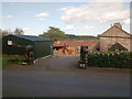
6
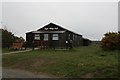
Stape Village Hall
Stape is not a village as such; it is more of a small, loose collection of farms and other dwellings. Given this it is surprising that it has its own village hall. The village hall is obviously maintained well and is, no doubt, an asset to Stape and possibly nearby villages.
Image: © Steve Partridge
Taken: 13 Apr 2008
0.10 miles
7
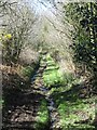
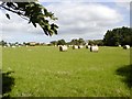
Soggy track at Stape
The track begins at the northern end as a relatively wide route with muddy puddles in tractor ruts. Any hopes that it might improve as one heads south are soon dashed as the way becomes constricted between thorny bushes, whilst the track itself tends to become a stream bed or just a mini swamp. A route best avoided - even during periods of dry weather.
Image: © Gordon Hatton
Taken: 25 Mar 2019
0.10 miles
8
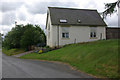
Former Chapel at Stape
Still shown as a chapel on the 1975 1:50000 map, this building is now a residence.
First shown as a Wesleyan Methodists Chapel on the 1891 Map of the North Riding.
Image: © Stephen McKay
Taken: 27 May 2007
0.11 miles

