IMAGES TAKEN NEAR TO
Stape, PICKERING, YO18 8HT
Introduction
This page details the photographs taken nearby to YO18 8HT by members of the Geograph project.
The Geograph project started in 2005 with the aim of publishing, organising and preserving representative images for every square kilometre of Great Britain, Ireland and the Isle of Man.

There are currently over 7.5m images from over14,400 individuals and you can help contribute to the project by visiting https://www.geograph.org.uk
Image Map
Images are licensed for reuse under creativecommons.org/licenses/by-sa/2.0
Notes
- Clicking on the map will re-center to the selected point.
- The higher the marker number, the further away the image location is from the centre of the postcode.
Image Listing (17 Images Found)
Images are licensed for reuse under creativecommons.org/licenses/by-sa/2.0
Image
Details
Distance
1
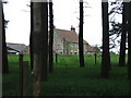
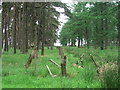
Brown Howe.
Looking W from the footpath through the woods.
Image: © Steve Partridge
Taken: 18 Jun 2006
0.06 miles
2
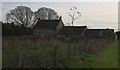
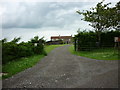
Lower Brownhouse Farmhouse
Shown as Brown Howe on the map - but the name at the gate is as in the title
Image: © Colin Grice
Taken: 29 Oct 2006
0.06 miles
3
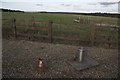
Environment Agency Raingauge
This is located North of the forest drive road by the entrance to Lower Brownhouse Farmhouse. http://www.geograph.org.uk/photo/269032
Image: © Colin Grice
Taken: 29 Oct 2006
0.07 miles
4
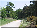
Forest Drive
Looking NE from the SW corner of the grid square along the Forest Drive in Cropton Forest.
Image: © Stephen Horncastle
Taken: 10 Jun 2006
0.08 miles

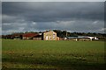
9
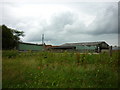
Farm at Brown Howe (1)
The OS map clearly shows a wall or a fence running across this field just to the left of the farm house. I never saw it.
Image: © Steve Partridge
Taken: 1 Mar 2008
0.12 miles
10
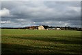
Farm at Brown Howe (2)
The wall or fence marked by OS across this field doesn't exist.
Image: © Steve Partridge
Taken: 1 Mar 2008
0.12 miles