IMAGES TAKEN NEAR TO
Wrelton, PICKERING, YO18 8HF
Introduction
This page details the photographs taken nearby to YO18 8HF by members of the Geograph project.
The Geograph project started in 2005 with the aim of publishing, organising and preserving representative images for every square kilometre of Great Britain, Ireland and the Isle of Man.

There are currently over 7.5m images from over14,400 individuals and you can help contribute to the project by visiting https://www.geograph.org.uk
Image Map
Images are licensed for reuse under creativecommons.org/licenses/by-sa/2.0
Notes
- Clicking on the map will re-center to the selected point.
- The higher the marker number, the further away the image location is from the centre of the postcode.
Image Listing (7 Images Found)
Images are licensed for reuse under creativecommons.org/licenses/by-sa/2.0
Image
Details
Distance
1
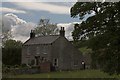
Coppice Farm
Small Farm near to Wrelton.
Image: © Colin Grice
Taken: 30 May 2006
0.02 miles
2
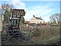
Coppice Farm
Farm house and yard with a couple of battered old tractors.
Image: © Gordon Hatton
Taken: 25 Feb 2015
0.03 miles
3
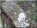
Ordnance Survey Cut Mark
This mark can be found on a recumbent gatepost in Coppice Lane.
For more detail see : http://www.bench-marks.org.uk/bm46306
Image: © Peter Wood
Taken: 24 Nov 2012
0.07 miles
4
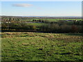
Near Coppice Farm
Looking SE across the Vale of Pickering towards The Wolds in the distance.
Image: © T Eyre
Taken: 20 Nov 2021
0.08 miles
5
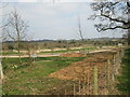
Holiday park construction
Ponds are being dug out at this holiday park.
Image: © T Eyre
Taken: 8 Apr 2015
0.16 miles
6
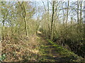
Dams Lane
This old route is a well used path although it is not an official right of way.
Image: © T Eyre
Taken: 28 Feb 2021
0.24 miles
7
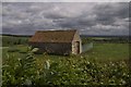
Small field barn near Hankow
In 2009 it had been converted into a small house.
Image: © Colin Grice
Taken: 30 May 2006
0.24 miles