IMAGES TAKEN NEAR TO
Cropton, PICKERING, YO18 8ER
Introduction
This page details the photographs taken nearby to YO18 8ER by members of the Geograph project.
The Geograph project started in 2005 with the aim of publishing, organising and preserving representative images for every square kilometre of Great Britain, Ireland and the Isle of Man.

There are currently over 7.5m images from over14,400 individuals and you can help contribute to the project by visiting https://www.geograph.org.uk
Image Map
Images are licensed for reuse under creativecommons.org/licenses/by-sa/2.0
Notes
- Clicking on the map will re-center to the selected point.
- The higher the marker number, the further away the image location is from the centre of the postcode.
Image Listing (28 Images Found)
Images are licensed for reuse under creativecommons.org/licenses/by-sa/2.0
Image
Details
Distance
1
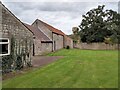
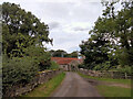
Part of the Farm at Lower Askew
Part of a tiny hamlet centred around Ings Bridge in the North York Moors National Park
Image: © Chris Heaton
Taken: 24 Sep 2023
0.03 miles
2
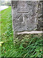
Bench Mark, Lower Askew Farm
The bench mark is to be found on the angle of the barn. For a wider view of the Image and for further information on the bench mark http://www.bench-marks.org.uk/bm36051
Image: © Maigheach-gheal
Taken: 8 Oct 2010
0.03 miles
3
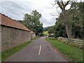
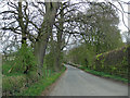
Lower Askew
Quiet country lane heading over Ings Beck towards Appleton-le-Moors
Image: © Chris Heaton
Taken: 24 Sep 2023
0.04 miles
4
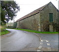
Barn, Lower Askew Farm
On the angle of the stone barn is an Ordnance Survey bench mark.
Image: © Maigheach-gheal
Taken: 8 Oct 2010
0.05 miles
5
Birk Head Lane
Crossing Ings Beck at Lower Askew on a quiet narrow lane from Appleton-le-Moors
Image: © Chris Heaton
Taken: 24 Sep 2023
0.05 miles
6
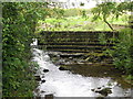
Dam, Ings Beck
I couldn't really work out if this small dam served a useful purpose or not.
Image: © Maigheach-gheal
Taken: 8 Oct 2010
0.05 miles
7
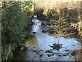
Ings Beck
Taken from the bridge at Lower Askew.
Image: © T Eyre
Taken: 12 Jan 2022
0.06 miles
8
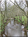
River Seven - upstream
NW view from Seven Bridge.
Image: © Pauline E
Taken: 16 Apr 2011
0.07 miles
9
Seven Bridge
Carrying the road from Lastingham to Cropton over the River Seven.
Image: © Pauline E
Taken: 16 Apr 2011
0.08 miles
10
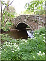
Seven Bridge
Seven Bridge crosses the small river of the same name between Cropton and Lastingham. The bridge is late 18th century and most likely by John Carr who was bridge engineer for the North Riding at the time.
Image: © Gordon Hatton
Taken: 28 May 2013
0.08 miles