IMAGES TAKEN NEAR TO
Malton Road, PICKERING, YO18 8EA
Introduction
This page details the photographs taken nearby to Malton Road, YO18 8EA by members of the Geograph project.
The Geograph project started in 2005 with the aim of publishing, organising and preserving representative images for every square kilometre of Great Britain, Ireland and the Isle of Man.

There are currently over 7.5m images from over14,400 individuals and you can help contribute to the project by visiting https://www.geograph.org.uk
Image Map
Images are licensed for reuse under creativecommons.org/licenses/by-sa/2.0
Notes
- Clicking on the map will re-center to the selected point.
- The higher the marker number, the further away the image location is from the centre of the postcode.
Image Listing (8 Images Found)
Images are licensed for reuse under creativecommons.org/licenses/by-sa/2.0
Image
Details
Distance
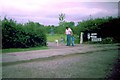
1
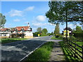
The Black Bull A169 Near Pickering
Brignam Park a private 9 hole golf course, and Upper Carr Caravan Park, is nearby.
Image: © Phil Catterall
Taken: 23 May 2006
0.04 miles
2
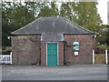
Pickering Carr Methodist Chapel
Alongside the busy A169.
Image: © Martin Dawes
Taken: 30 Sep 2009
0.04 miles
4
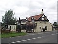
The Black Bull
On the A169 south of Pickering.
Image: © Ian S
Taken: 27 May 2017
0.08 miles
5
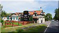
Pickering - 1989
Pickering, Carr, Black Bull Camping Site.
Image: © Helmut Zozmann
Taken: Unknown
0.09 miles
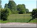
8

Tall trees at the caravan and camping site
Upper Carr Holiday Park also has a friendly tearoom.
Image: © Pauline E
Taken: 6 Sep 2012
0.12 miles