IMAGES TAKEN NEAR TO
Train Lane, PICKERING, YO18 8DX
Introduction
This page details the photographs taken nearby to Train Lane, YO18 8DX by members of the Geograph project.
The Geograph project started in 2005 with the aim of publishing, organising and preserving representative images for every square kilometre of Great Britain, Ireland and the Isle of Man.

There are currently over 7.5m images from over14,400 individuals and you can help contribute to the project by visiting https://www.geograph.org.uk
Image Map
Images are licensed for reuse under creativecommons.org/licenses/by-sa/2.0
Notes
- Clicking on the map will re-center to the selected point.
- The higher the marker number, the further away the image location is from the centre of the postcode.
Image Listing (631 Images Found)
Images are licensed for reuse under creativecommons.org/licenses/by-sa/2.0
Image
Details
Distance


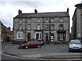
8

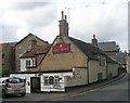
Beckside Gifts, Clothing & Tea Rooms - Bridge Street
Image: © Betty Longbottom
Taken: 9 Sep 2010
0.03 miles
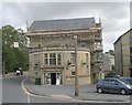
9
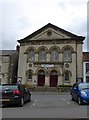
Primitive Methodist chapel, Pickering
Dated 1885
Image: © David Smith
Taken: 19 Jun 2015
0.03 miles