IMAGES TAKEN NEAR TO
Aunums Close, PICKERING, YO18 7TP
Introduction
This page details the photographs taken nearby to Aunums Close, YO18 7TP by members of the Geograph project.
The Geograph project started in 2005 with the aim of publishing, organising and preserving representative images for every square kilometre of Great Britain, Ireland and the Isle of Man.

There are currently over 7.5m images from over14,400 individuals and you can help contribute to the project by visiting https://www.geograph.org.uk
Image Map
Images are licensed for reuse under creativecommons.org/licenses/by-sa/2.0
Notes
- Clicking on the map will re-center to the selected point.
- The higher the marker number, the further away the image location is from the centre of the postcode.
Image Listing (45 Images Found)
Images are licensed for reuse under creativecommons.org/licenses/by-sa/2.0
Image
Details
Distance
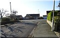
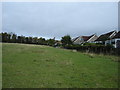
3
The part tourists do not see
Broadmires Lane into Thornton le Dale at the southern edge of the village, to the north where the A170 goes through the village hordes of tourists will be milling about.
Image: © Martin Dawes
Taken: 30 Sep 2009
0.08 miles
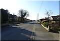
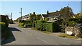
4
West Gate
Looking towards Pickering, newly built houses on the right.
Image: © T Eyre
Taken: 18 Mar 2016
0.09 miles

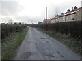
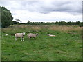
6
Footpath on the western fringe of village
Footpath from Broadmires Lane turning right into the village at the top of this field.
Image: © Martin Dawes
Taken: 30 Sep 2009
0.14 miles
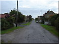
7
Roxby Road
This westerly facing photograph shows the junction of Roxby Road (ahead) with Image (immediate foreground).
Ahead Roxby Road bears to the right at a junction with The Rise (to the left) and The Mount (straight on). The houses (ahead) are in The Mount.
Image: © Alan Walker
Taken: 1 May 2007
0.15 miles
9
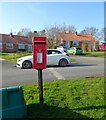
NEW
Elizabeth II postox on Castle Road, Thornton-le-Dale
Image: © JThomas
Taken: 8 Mar 2025
0.16 miles
10
NEW
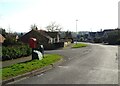
Castle Road, Thornton-le-Dale
Showing position of Postbox No. YO18 135.
See Image] for postbox.
Image: © JThomas
Taken: 8 Mar 2025
0.16 miles