IMAGES TAKEN NEAR TO
The Rise, PICKERING, YO18 7TG
Introduction
This page details the photographs taken nearby to The Rise, YO18 7TG by members of the Geograph project.
The Geograph project started in 2005 with the aim of publishing, organising and preserving representative images for every square kilometre of Great Britain, Ireland and the Isle of Man.

There are currently over 7.5m images from over14,400 individuals and you can help contribute to the project by visiting https://www.geograph.org.uk
Image Map
Images are licensed for reuse under creativecommons.org/licenses/by-sa/2.0
Notes
- Clicking on the map will re-center to the selected point.
- The higher the marker number, the further away the image location is from the centre of the postcode.
Image Listing (64 Images Found)
Images are licensed for reuse under creativecommons.org/licenses/by-sa/2.0
Image
Details
Distance
1
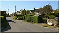
Roxby Road
This westerly facing photograph shows the junction of Roxby Road (ahead) with Image (immediate foreground).
Ahead Roxby Road bears to the right at a junction with The Rise (to the left) and The Mount (straight on). The houses (ahead) are in The Mount.
Image: © Alan Walker
Taken: 1 May 2007
0.05 miles
2

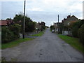
Malton Gate
The photograph is looking in a northerly direction along Malton Gate and was taken from near its junction with Image (left, behind the viewpoint).
Ahead Malton Gate leads toward Thornton village centre and the A170. Behind the viewpoint the road connects with the A169 via High Marishes.
The stream is one of the water courses for Thornton Beck.
For a more northerly (some 30metres ahead) photograph of Malton Gate but looking back, toward this viewpoint, click here Image
For a more southerly (behind the viewpoint) photograph of Malton Gate, click here Image
Image: © Alan Walker
Taken: 1 May 2007
0.08 miles
3
The part tourists do not see
Broadmires Lane into Thornton le Dale at the southern edge of the village, to the north where the A170 goes through the village hordes of tourists will be milling about.
Image: © Martin Dawes
Taken: 30 Sep 2009
0.09 miles
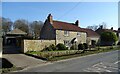
4

Beckside cottages
Looking north towards the village centre with cottages along the beck side on the right.
Image: © Gordon Hatton
Taken: 2 May 2021
0.09 miles
5
Building at Puddleduck Cottage
There is an Ordnance Survey benchmark on the west face of this building attached to Puddleduck Cottage. See https://www.geograph.org.uk/photo/6234941 for a closer view and https://www.bench-marks.org.uk/bm109226 for details.
Image: © Brian Westlake
Taken: 5 Jul 2019
0.09 miles
6

Cut Mark: Thornton-le-Dale, Puddleduck Cottage
Ordnance Survey benchmark on the west face of a building attached to Puddleduck Cottage. See https://www.geograph.org.uk/photo/6234943 for a wider view and https://www.bench-marks.org.uk/bm109226 for details.
Image: © Brian Westlake
Taken: 5 Jul 2019
0.09 miles
7

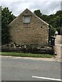
Thornton le Dale, Malton Gate Road
This gable end wall is on the east side of Malton Gate Road, and has a benchmark cut about 2 feet above ground level.
Image: © Mel Towler
Taken: 23 Feb 2022
0.09 miles
8
Thornton le Dale, Malton Gate Road
This gable end wall is on the east side of Malton Gate Road, and has a benchmark cut about 2 feet above ground level.
Image: © Mel Towler
Taken: 23 Feb 2022
0.09 miles
10
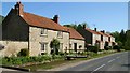
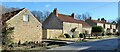
Malton Gate
This southerly facing photograph is looking along Malton Gate toward the village outskirts.
The concrete bridge (immediate, left foreground) leads to Bleach Mill (private).
The three detached properties ahead are part of a small housing development centred on Image (to their rear).
The stream in front of the buildings is one of the watercourses for Thornton Beck.
For a more southerly (ahead) photograph of Malton Gate, click here Image
For a more northerly (close by, behind the viewpoint) photograph of Malton Gate, click here Image
Image: © Alan Walker
Taken: 1 May 2007
0.09 miles