
IMAGES TAKEN NEAR TO
Willow Garth, PICKERING, YO18 7SW
Introduction
This page details the photographs taken nearby to Willow Garth, YO18 7SW by members of the Geograph project.
The Geograph project started in 2005 with the aim of publishing, organising and preserving representative images for every square kilometre of Great Britain, Ireland and the Isle of Man.

There are currently over 7.5m images from over14,400 individuals and you can help contribute to the project by visiting https://www.geograph.org.uk
Image Map
Images are licensed for reuse under creativecommons.org/licenses/by-sa/2.0
Notes
- Clicking on the map will re-center to the selected point.
- The higher the marker number, the further away the image location is from the centre of the postcode.
Image Listing (55 Images Found)
Images are licensed for reuse under creativecommons.org/licenses/by-sa/2.0
Image
Details
Distance
1

Beckside cottages
Looking north towards the village centre with cottages along the beck side on the right.
Image: © Gordon Hatton
Taken: 2 May 2021
0.03 miles
2

Elizabeth II postox on Heron Close, Thornton-le-Dale
Image: © JThomas
Taken: 8 Mar 2025
0.03 miles
3

Close up, Elizabeth II postox on Heron Close, Thornton-le-Dale
Image: © JThomas
Taken: 8 Mar 2025
0.03 miles
4
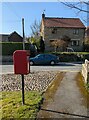
House on House on Thornton Lane, Thornton-le-Dale
Showing position of Postbox No. YO18 82.
See Image] for postbox.
Image: © JThomas
Taken: 8 Mar 2025
0.04 miles
5

Path beside Heron Close, Thornton-le-Dale
Showing position of Postbox No. YO18 82.
See Image] for postbox.
Image: © JThomas
Taken: 8 Mar 2025
0.04 miles
6

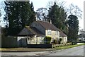
Malton Gate
The photograph is looking in a northerly direction along Malton Gate.
Ahead Malton Gate leads toward Thornton village centre and the A170. Behind the viewpoint the road connects with the A169 via High Marishes.
The junction on the left is with Westgate.
The wet section of road is from the junction with a Image on the right that is used to connect Bottoms Lane and a number of private properties with the main road.
For a more northerly (ahead) photograph of Malton Gate, click here Image
Image: © Alan Walker
Taken: 1 May 2007
0.04 miles
8
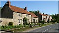
Malton Gate
This southerly facing photograph is looking along Malton Gate toward the village outskirts.
The concrete bridge (immediate, left foreground) leads to Bleach Mill (private).
The three detached properties ahead are part of a small housing development centred on Image (to their rear).
The stream in front of the buildings is one of the watercourses for Thornton Beck.
For a more southerly (ahead) photograph of Malton Gate, click here Image
For a more northerly (close by, behind the viewpoint) photograph of Malton Gate, click here Image
Image: © Alan Walker
Taken: 1 May 2007
0.05 miles
9
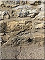
Cut Mark: Thornton-le-Dale, Heron Cottage
Cut benchmark on a cottage on the north side of a ford. A footbridge gives easy access to the side of the cottage with the mark. See https://www.geograph.org.uk/photo/6225495 for a wider view and https://www.bench-marks.org.uk/bm109225 for details of the mark.
Image: © Brian Westlake
Taken: 3 Jul 2019
0.05 miles
10
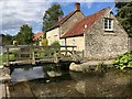
Thornton-le-Dale, cottage by a ford
There is a cut benchmark on this cottage on the north side of a ford. See https://www.geograph.org.uk/photo/6225494 for a closer view and https://www.bench-marks.org.uk/bm109225 for details of the mark.
Image: © Brian Westlake
Taken: 3 Jul 2019
0.05 miles