IMAGES TAKEN NEAR TO
Allerston, PICKERING, YO18 7PN
Introduction
This page details the photographs taken nearby to YO18 7PN by members of the Geograph project.
The Geograph project started in 2005 with the aim of publishing, organising and preserving representative images for every square kilometre of Great Britain, Ireland and the Isle of Man.

There are currently over 7.5m images from over14,400 individuals and you can help contribute to the project by visiting https://www.geograph.org.uk
Image Map
Images are licensed for reuse under creativecommons.org/licenses/by-sa/2.0
Notes
- Clicking on the map will re-center to the selected point.
- The higher the marker number, the further away the image location is from the centre of the postcode.
Image Listing (7 Images Found)
Images are licensed for reuse under creativecommons.org/licenses/by-sa/2.0
Image
Details
Distance
3
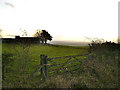
Vale of Pickering mist
Mist hangs in the Vale of Pickering although it is clear higher up on the moors.
Image: © T Eyre
Taken: 26 Nov 2020
0.07 miles

5

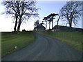
The road down to Allerston from Warren House
Image: © Phil Catterall
Taken: 6 Dec 2006
0.08 miles
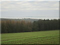
6

Warren House farm
Campin field at Warren House with campers packing at the end of a holiday week. Warren House most likely is on the site of a medieval or later rabbit warren, of which there are several on the Tabular Hills.
Image: © Gordon Hatton
Taken: 2 Jun 2013
0.12 miles
7
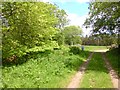
Forest track, Stonygate Moor
The main item of interest in this photo is the elm tree in flower to the left. A rare enough sight these days.
Image: © Gordon Hatton
Taken: 2 Jun 2013
0.25 miles