IMAGES TAKEN NEAR TO
Lockton, PICKERING, YO18 7NU
Introduction
This page details the photographs taken nearby to YO18 7NU by members of the Geograph project.
The Geograph project started in 2005 with the aim of publishing, organising and preserving representative images for every square kilometre of Great Britain, Ireland and the Isle of Man.

There are currently over 7.5m images from over14,400 individuals and you can help contribute to the project by visiting https://www.geograph.org.uk
Image Map
Images are licensed for reuse under creativecommons.org/licenses/by-sa/2.0
Notes
- Clicking on the map will re-center to the selected point.
- The higher the marker number, the further away the image location is from the centre of the postcode.
Image Listing (7 Images Found)
Images are licensed for reuse under creativecommons.org/licenses/by-sa/2.0
Image
Details
Distance
1
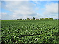
Whitethorn over a Turnip Field
From the footpath past Whitethorn over to Crosscliff
Image: © Martin Dawes
Taken: 21 Aug 2011
0.01 miles
2
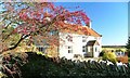
Whitethorn and Hawthorn
Whitethorn is the name of the cottage.
Image: © Mick Garratt
Taken: 9 Dec 2006
0.04 miles
3
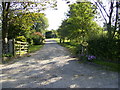
Drive to Newstead Farm
The farm and driveway is not shown on the 2005 OS Explorer Map.
Image: © Phil Catterall
Taken: 3 Aug 2007
0.05 miles
4

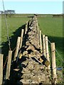
Lichen Covered Hedge, Pasture Lane
With the farm High Pastures just visible in the distance.
Image: © Mick Garratt
Taken: 9 Dec 2006
0.10 miles
5
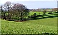
Fields, Pasture Rigg
South westerly view from the north eastern corner of this square, from where Pasture Lane just nicks the corner. The dry valley flows into Rustifhead Slack. Pasture Rigg is the high ground on the far side of the valley.
Image: © Mick Garratt
Taken: 9 Dec 2006
0.14 miles
6
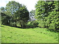
Footpath to Whitethorn
The footpath from High Pastures Farm runs through this dale to the stile in the centre of the photo.
Image: © Martin Dawes
Taken: 21 Aug 2011
0.16 miles