IMAGES TAKEN NEAR TO
Saltersgate, PICKERING, YO18 7NR
Introduction
This page details the photographs taken nearby to YO18 7NR by members of the Geograph project.
The Geograph project started in 2005 with the aim of publishing, organising and preserving representative images for every square kilometre of Great Britain, Ireland and the Isle of Man.

There are currently over 7.5m images from over14,400 individuals and you can help contribute to the project by visiting https://www.geograph.org.uk
Image Map
Images are licensed for reuse under creativecommons.org/licenses/by-sa/2.0
Notes
- Clicking on the map will re-center to the selected point.
- The higher the marker number, the further away the image location is from the centre of the postcode.
Image Listing (5 Images Found)
Images are licensed for reuse under creativecommons.org/licenses/by-sa/2.0
Image
Details
Distance
1
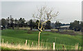
Farm buildings
Marfit Head Farm off the A169.
Image: © Pauline E
Taken: 18 Feb 2014
0.05 miles
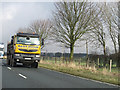
2
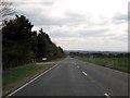
Passing Little Marfit Head farm on the A169
The farm access road to the left, this long straight is toward Pickering, sheep and cattle rearing on grassland up here
Image: © Martin Dawes
Taken: 5 Apr 2017
0.06 miles
3
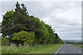
Trees screening camping site at Marfit Head
The trees on the left are part of a screen which shelters the farm and camping site from west, north and south. A small part of the site is also sheltered from the east
Image: © David Smith
Taken: 14 Jun 2015
0.16 miles
4
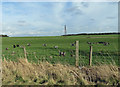
Field with goats
Grazing in the valley beneath the power lines.
Image: © Pauline E
Taken: 25 Feb 2014
0.22 miles
5
Peacock on the road
A169 near Marfit Head Farm.
Image: © Pauline E
Taken: 18 Feb 2014
0.23 miles