IMAGES TAKEN NEAR TO
Alma Way, PICKERING, YO18 7JH
Introduction
This page details the photographs taken nearby to Alma Way, YO18 7JH by members of the Geograph project.
The Geograph project started in 2005 with the aim of publishing, organising and preserving representative images for every square kilometre of Great Britain, Ireland and the Isle of Man.

There are currently over 7.5m images from over14,400 individuals and you can help contribute to the project by visiting https://www.geograph.org.uk
Image Map
Images are licensed for reuse under creativecommons.org/licenses/by-sa/2.0
Notes
- Clicking on the map will re-center to the selected point.
- The higher the marker number, the further away the image location is from the centre of the postcode.
Image Listing (47 Images Found)
Images are licensed for reuse under creativecommons.org/licenses/by-sa/2.0
Image
Details
Distance
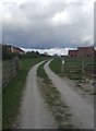
3

Forest Road at junction with Ruffa Lane
Image: © Martin Dawes
Taken: 27 May 2021
0.14 miles
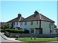
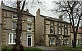
4

Ruffa Lane, Pickering
Houses in Ruffa Lane.
Image: © Mary and Angus Hogg
Taken: 22 Apr 2012
0.15 miles
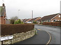
6
Pickering Community Infant & Nursery School
Located at the end of Ruffa Lane.
Image: © Mary and Angus Hogg
Taken: 22 Apr 2012
0.17 miles
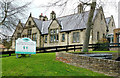
7
Pickering, 42 Eastgate
The benchmark is cut into the west facing wall of the property, and is cut into a right hand cornerstone.
Image: © Mel Towler
Taken: 16 Mar 2022
0.17 miles
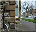
8
Pickering, 42 Eastgate
There is a benchmark cut into the west facing wall of the property, and is cut into a right hand cornerstone.
Image: © Mel Towler
Taken: 16 Mar 2022
0.17 miles
9
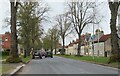
Eastgate, Pickering
The main road from the east into Pickering at the point where 20th century housing either side gives way to older properties.
Image: © Gordon Hatton
Taken: 2 May 2021
0.19 miles
10
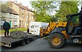
The Hooping Plate
This iron hooping plate was being moved from its former site in Eastgate to its new home at Beck Isle Museum, in Pickering. The plate had been used by wheelwrights John Willy Dale, and his sons Tommy and Dickie Dale,until they died. Red hot steel hoops or tyres, were fitted onto wooden cart wheels using this plate before being cooled with water in order to shrink them onto the wheels.
Image: © gordon clitheroe
Taken: 20 Apr 2011
0.19 miles