IMAGES TAKEN NEAR TO
Thornton Road Industrial Estate, Thornton Road, PICKERING, YO18 7JB
Introduction
This page details the photographs taken nearby to Thornton Road Industrial Estate, Thornton Road, YO18 7JB by members of the Geograph project.
The Geograph project started in 2005 with the aim of publishing, organising and preserving representative images for every square kilometre of Great Britain, Ireland and the Isle of Man.

There are currently over 7.5m images from over14,400 individuals and you can help contribute to the project by visiting https://www.geograph.org.uk
Image Map
Images are licensed for reuse under creativecommons.org/licenses/by-sa/2.0
Notes
- Clicking on the map will re-center to the selected point.
- The higher the marker number, the further away the image location is from the centre of the postcode.
Image Listing (6 Images Found)
Images are licensed for reuse under creativecommons.org/licenses/by-sa/2.0
Image
Details
Distance
1
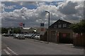
Thornton Road Industrial Estate
At the Eastern end of Pickering, just off the A170.
Image: © Colin Grice
Taken: 30 May 2006
0.05 miles
2
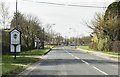
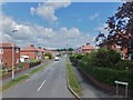
A170 Thornton Road entering Pickering
Image: © J.Hannan-Briggs
Taken: 15 Mar 2017
0.07 miles
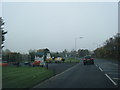
4

New building at Thornton road industrial estate
These are at the South West corner of the estate.
Image: © Colin Grice
Taken: 4 Jan 2007
0.14 miles
5
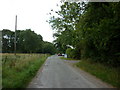
A short walk around the Vale of Pickering #4
Outgang Lane, Pickering.
Image: © Ian S
Taken: 4 Sep 2010
0.23 miles
6
Whitfield Avenue, Pickering
Residential area on the eastern edge of Pickering.
Image: © Barbara Carr
Taken: 16 Jun 2013
0.24 miles