IMAGES TAKEN NEAR TO
The Stonebow, YORK, YO1 7NP
Introduction
This page details the photographs taken nearby to The Stonebow, YO1 7NP by members of the Geograph project.
The Geograph project started in 2005 with the aim of publishing, organising and preserving representative images for every square kilometre of Great Britain, Ireland and the Isle of Man.

There are currently over 7.5m images from over14,400 individuals and you can help contribute to the project by visiting https://www.geograph.org.uk
Image Map
Images are licensed for reuse under creativecommons.org/licenses/by-sa/2.0
Notes
- Clicking on the map will re-center to the selected point.
- The higher the marker number, the further away the image location is from the centre of the postcode.
Image Listing (2292 Images Found)
Images are licensed for reuse under creativecommons.org/licenses/by-sa/2.0
Image
Details
Distance
1
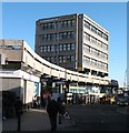
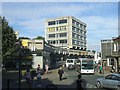
York's monstrosity
The ghastly concrete monstrosity of Stonebow House and car park in York city centre, situated just a few yards from elegant 18thC houses in St Saviourgate and the historic Shambles. The building looks like something from one of the cities in the old East Germany.
Image: © Gordon Hatton
Taken: 30 Jan 2008
0.01 miles
2

Towards DIG
This street runs behind Stonebow with the Church used for York DIG ahead.
Image: © DS Pugh
Taken: 4 Aug 2024
0.01 miles
3

Stonebow House, Stonebow, York
Built in 1964 by Wells, Hickman & Partners, the development incorporating a four-storey tower, shops and car parking. It is probably considered by many to be York's ugliest building but the details and materials are actually good quality. It suffers more from its otherwise genteel setting. Demolition may be the favoured approach, but with a bit of TLC it could be re-born and, who knows, become one of York's most beautiful buildings
Image: © Stephen Richards
Taken: 14 May 2013
0.01 miles
4
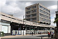
Stonebow House, York
Built in 1965 and designed by Wells, Hickman and Partners.
Image: © Andrew Abbott
Taken: 6 Aug 2016
0.01 miles
6

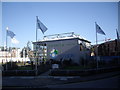
Clock tower on converted church
Viewed from adjacent multi-storey car park. The former St Saviour's mediaeval church is now an Archaeological Resource Centre (DIG). See http://imagesofyork.blogspot.com/2009/08/st-saviours-church-dig.html .
Image: © Stanley Howe
Taken: 26 Sep 2009
0.02 miles
7
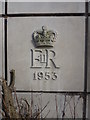
York Townscape : 1953, A Great Year
A great year for telephone exchanges.
Located at knee level on the NW staircase elevation of the telephone exchange on The Stonebow and Garden Place.
Image: © Richard West
Taken: 26 Apr 2017
0.02 miles
8
Woolpack House - The Stonebow
One of a number of concrete office buildings within the city walls.
Image: © John M
Taken: 9 Aug 2012
0.03 miles
9

York - Coastliner Bus
Route 840 York-Pickering-Whitby preparing to depart from Stonegate. Note the £2 fare advertised on the front - a flat low fare was introduced across England to encourage folk to use buses more following the Covid pandemic.
The bus is operated by Transdev, a nationwide concern owned by the French company RATP.
Image: © Colin Smith
Taken: 10 Jul 2024
0.03 miles
10
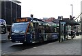
York Electric bus on Stonebow
On route 9 to Monks Cross Park & Ride.
Image: © JThomas
Taken: 23 Feb 2024
0.03 miles