IMAGES TAKEN NEAR TO
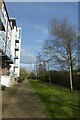
Palmer Street, YORK, YO1 7NF
Introduction
This page details the photographs taken nearby to Palmer Street, YO1 7NF by members of the Geograph project.
The Geograph project started in 2005 with the aim of publishing, organising and preserving representative images for every square kilometre of Great Britain, Ireland and the Isle of Man.

There are currently over 7.5m images from over14,400 individuals and you can help contribute to the project by visiting https://www.geograph.org.uk
Image Map
Images are licensed for reuse under creativecommons.org/licenses/by-sa/2.0
Notes
- Clicking on the map will re-center to the selected point.
- The higher the marker number, the further away the image location is from the centre of the postcode.
Image Listing (767 Images Found)
Images are licensed for reuse under creativecommons.org/licenses/by-sa/2.0
Image
Details
Distance
1
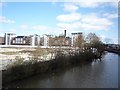
Across the Hungate site
New flats have been built on the Hungate redevelopment so far, the remainder of the site remains vacant and cleared. Taken from the path along the flats of the converted Rowntree Wharfe.
Image: © DS Pugh
Taken: 27 Mar 2010
0.02 miles
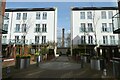
2
Pond Garth
Looking along a path between blocks of flats on the Hungate site.
Image: © DS Pugh
Taken: 19 Mar 2023
0.02 miles
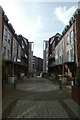
3
Palmer Street and Pound Lane
Looking onto Pound Lane beside Leetham House.
Image: © DS Pugh
Taken: 26 Aug 2022
0.02 miles
4
Flats at Hungate
With the Foss Islands Chimney framed between the flats.
Image: © DS Pugh
Taken: 19 Mar 2023
0.03 miles
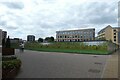
5
Foss View
Looking along a path between a block of flats and the River Foss.
Image: © DS Pugh
Taken: 19 Mar 2023
0.03 miles
6

Hungate footbridge - looking north along Palmer Street
A cable-stayed foot- and cycle-bridge opened in 2011 to link Palmer Street with Navigation Road over the River Foss.
Image: © Oliver Dixon
Taken: 11 Dec 2019
0.03 miles
7
Hungate footbridge and Leetham House
A cable-stayed foot- and cycle-bridge opened in 2011 to link Palmer Street with Navigation Road over the River Foss. Leetham House is an apartment block.
Image: © Oliver Dixon
Taken: 11 Dec 2019
0.03 miles
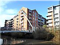
8

New bridge over the River Foss
A new route for pedestrians and cyclists close to the city centre. On the right are some of the new apartment blocks on the SE side of Peaseholme Green, whilst to the left is land awaiting development.
Image: © Gordon Hatton
Taken: 16 Jul 2013
0.04 miles
9
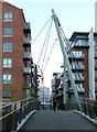
Hungate Bridge
Hungate Bridge opened in 2011 to provide an entirely new pedestrian route across the River Foss. It is part of a major redevelopment with housing in the former industrial area immediately to the south of the City centre.
Image: © Alan Murray-Rust
Taken: 9 Dec 2018
0.04 miles
10
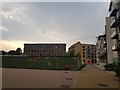
Construction at Hungate
Building work continues in this area of the city.
Image: © DS Pugh
Taken: 27 Aug 2019
0.04 miles