IMAGES TAKEN NEAR TO
Bartle Garth, YORK, YO1 7AL
Introduction
This page details the photographs taken nearby to Bartle Garth, YO1 7AL by members of the Geograph project.
The Geograph project started in 2005 with the aim of publishing, organising and preserving representative images for every square kilometre of Great Britain, Ireland and the Isle of Man.

There are currently over 7.5m images from over14,400 individuals and you can help contribute to the project by visiting https://www.geograph.org.uk
Image Map
Images are licensed for reuse under creativecommons.org/licenses/by-sa/2.0
Notes
- Clicking on the map will re-center to the selected point.
- The higher the marker number, the further away the image location is from the centre of the postcode.
Image Listing (2913 Images Found)
Images are licensed for reuse under creativecommons.org/licenses/by-sa/2.0
Image
Details
Distance
1
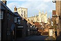
Minster over Battlegarth
Looking along Battlegarth from St. Andrewsgate with the Minster clearly visible on the skyline.
Image: © DS Pugh
Taken: 29 Jan 2017
0.01 miles
2
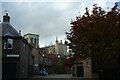
Turks Head Court
Looking along a street in the city centre with the Minster dominating the skyline.
Image: © DS Pugh
Taken: 25 Oct 2020
0.01 miles
3
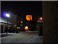
Bartle Garth
Looking across Bedern towards the illuminated Minster.
Image: © DS Pugh
Taken: 9 Dec 2010
0.01 miles
4
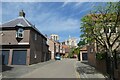
Bartle Garth
Looking along Bartle Garth near St. Andrewgate with the Minster in the background.
Image: © DS Pugh
Taken: 18 Jun 2022
0.02 miles
5
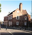
Georgian House in St Andrewgate
A restored property dating back to around 1740, now almost surrounded by newer development.
Image: © Gordon Hatton
Taken: 30 Jan 2008
0.02 miles
6
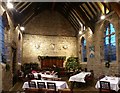
Bedern Hall, the interior
Bedern Hall, built in the 14th Century, was part of the community of the Vicars Choral of York, but had been 'lost' among the later development of the area after the Reformation. It was 'resurrected' in the late 20th century and restored in 1983 to become a functions hall. It also serves as Guild hall for a number of the City's Guilds. Listed Grade II*. The one window retaining original tracery is of a very unusual pattern with simple mullion and transom.
On the far wall can be seen the badges of the three Guilds which use the Hall. From left to right they are the Cordwainers, Builders and Freemen, the boards below being inscribed with the names of the Guild Masters.
Image: © Alan Murray-Rust
Taken: 10 Dec 2017
0.02 miles
7
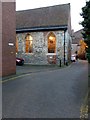
Bartle Garth with Bedern Hall
Bedern Hall, built in the 14th Century, was part of the community of the Vicars Choral of York, but had been 'lost' among the later development of the area after the Reformation. It was 'resurrected' in the late 20th century and restored in 1983 to become a functions hall. It also serves as Guild hall for a number of the City's Guilds. Listed Grade II*. The one widow retaining original tracery is of a very unusual pattern with simple mullion and transom.
Image: © Alan Murray-Rust
Taken: 10 Dec 2017
0.02 miles
8
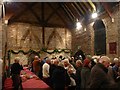
Bedern Hall, interior
This view shows the 14th century timber framing at the south-east end of the hall. Listed Grade II*.
See http://www.geograph.org.uk/photo/5625796 for more information.
Image: © Alan Murray-Rust
Taken: 10 Dec 2017
0.02 miles
9
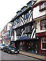
Half timbered buildings in Goodramgate
Half timbered building in Goodramgate now occupied by a restaurant. The building was restored in the early 20thC.
Image: © Gordon Hatton
Taken: 30 Jan 2008
0.02 miles
10
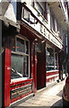
The Snickleway Inn, 47 Goodramgate, York
This pub is one of the oldest in York. It has changed its name many times including from the 18th century the Painters Arms, Square & Compass, and Board. Most recently from 1896 to 1994 it was known as the Angler's Arms. The present name dates from 1994 and is apparently a deliberate misspelling of Snickelway to avoid breaking Mark W Jones’ copyright from his 1983 book A Walk Around the Snickelways of York. The Grade II* Listed public house has a front range of about 1500. Originally it was a house; evidence suggests it may have once been used as a brothel as well as being the Royalist powder magazine during the English Civil War. It was known to be a pub in 1769 and there are records telling us they have had a kitchen and served food to the public for at least 100 years. Derek Acorah names the pub as being amongst Britain's 100 scariest places to visit, thought to be haunted by at least 5 spirits. From time to time the smell of lavender is said to emanate from the top floor, filling the whole pub. During the time of the plague, corpses were placed in the uppermost rooms. To cover the smell, the use of sweet smelling lavender was common. Directory entries include the following, addressed at the time as No.35 & 36 Goodramgate unless stated; 1841 Square & Compass, Richard Powell, No.35; 1851 William Cooper, no profession given; 1855 'Letters', William Cooper, No.35; 1885-1895 Edward Staines wine & spirit merchant & beer retailer in 1895; 1913 Angler's Arms, Mrs Mary Jane Marley. It is difficult to locate beerhouses in most directories as they don't often include names. It is strange to be listed as wine & spirit merchants and not be named as a pub. In 5 or 6 earlier directories I just couldn't locate the building at all. It seems to have been called 'Letters' in the mid 19th century.
Image: © Jo and Steve Turner
Taken: 11 Nov 2016
0.02 miles