IMAGES TAKEN NEAR TO
Leavening, MALTON, YO17 9SS
Introduction
This page details the photographs taken nearby to YO17 9SS by members of the Geograph project.
The Geograph project started in 2005 with the aim of publishing, organising and preserving representative images for every square kilometre of Great Britain, Ireland and the Isle of Man.

There are currently over 7.5m images from over14,400 individuals and you can help contribute to the project by visiting https://www.geograph.org.uk
Image Map
Images are licensed for reuse under creativecommons.org/licenses/by-sa/2.0
Notes
- Clicking on the map will re-center to the selected point.
- The higher the marker number, the further away the image location is from the centre of the postcode.
Image Listing (22 Images Found)
Images are licensed for reuse under creativecommons.org/licenses/by-sa/2.0
Image
Details
Distance
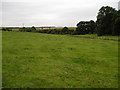
1
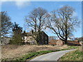
Aldro Farm
Big farmhouse with extensive barns and fold yard on the top of the Wolds at the 750ft contour. The farm is shown on the OS first edition maps of 1855.
Image: © Gordon Hatton
Taken: 15 Mar 2019
0.01 miles

3
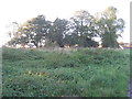
Aldro Farm
Hidden by trees, the tops of which catch the evening sun.
Image: © Jonathan Thacker
Taken: 15 Oct 2011
0.01 miles


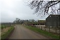
6
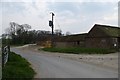
Farm buildings
Aldro Farm between Birdsall and Thixendale.
Image: © DS Pugh
Taken: 20 Apr 2014
0.04 miles
9

Aldro Farm
Between Birdsall and Thixendale.
Image: © DS Pugh
Taken: 20 Apr 2014
0.05 miles
10
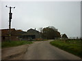
Passing Aldro Farm
The road leads to Thixendale through Water Dale.
Image: © DS Pugh
Taken: 11 Mar 2017
0.06 miles