IMAGES TAKEN NEAR TO
Menethorpe Lane, MALTON, YO17 9QY
Introduction
This page details the photographs taken nearby to Menethorpe Lane, YO17 9QY by members of the Geograph project.
The Geograph project started in 2005 with the aim of publishing, organising and preserving representative images for every square kilometre of Great Britain, Ireland and the Isle of Man.

There are currently over 7.5m images from over14,400 individuals and you can help contribute to the project by visiting https://www.geograph.org.uk
Image Map
Images are licensed for reuse under creativecommons.org/licenses/by-sa/2.0
Notes
- Clicking on the map will re-center to the selected point.
- The higher the marker number, the further away the image location is from the centre of the postcode.
Image Listing (6 Images Found)
Images are licensed for reuse under creativecommons.org/licenses/by-sa/2.0
Image
Details
Distance
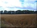
1
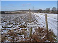
High Farm
View west along the farm track, a typical view of this grid square.
Image: © Stephen Horncastle
Taken: 4 Mar 2006
0.15 miles
2
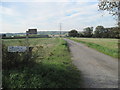
Access road to High Farm
They have obviously had problems with railway maintenance vehicles. No Access!!
Image: © Martin Dawes
Taken: 27 Sep 2011
0.20 miles
3
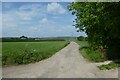
Track to High Farm
Looking along the track to High Farm from Menethorpe Lane.
Image: © DS Pugh
Taken: 14 May 2022
0.21 miles
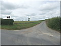
6
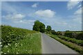
Menethorpe Lane
Looking along Menethorpe Lane to the north of the settlement.
Image: © DS Pugh
Taken: 14 May 2022
0.24 miles