IMAGES TAKEN NEAR TO
Ruffin Lane, MALTON, YO17 9QU
Introduction
This page details the photographs taken nearby to Ruffin Lane, YO17 9QU by members of the Geograph project.
The Geograph project started in 2005 with the aim of publishing, organising and preserving representative images for every square kilometre of Great Britain, Ireland and the Isle of Man.

There are currently over 7.5m images from over14,400 individuals and you can help contribute to the project by visiting https://www.geograph.org.uk
Image Map
Images are licensed for reuse under creativecommons.org/licenses/by-sa/2.0
Notes
- Clicking on the map will re-center to the selected point.
- The higher the marker number, the further away the image location is from the centre of the postcode.
Image Listing (16 Images Found)
Images are licensed for reuse under creativecommons.org/licenses/by-sa/2.0
Image
Details
Distance
1
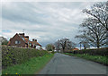
Entering Eddlethorpe
And leaving pretty swiftly. This is a tiny hamlet with just a handful of dwellings.
Image: © Pauline E
Taken: 24 Apr 2012
0.04 miles
2

Sheep pasture on Howlbeck Bank
Rainwater is collecting in the hollows.
Image: © Pauline E
Taken: 24 Apr 2012
0.05 miles
6
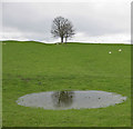
Tree on Howlbeck Bank
We've had a fair bit of rain in these parts recently.
Image: © Pauline E
Taken: 24 Apr 2012
0.12 miles
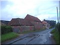
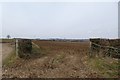
7

Towards Kennels Farm
Looking along the old Malton road.
Image: © DS Pugh
Taken: 7 Apr 2013
0.15 miles
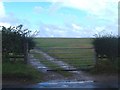
8
Farmland next to the Westow junction
Looking into a field off the old Malton road.
Image: © DS Pugh
Taken: 7 Apr 2013
0.17 miles
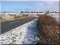
9

Road near Eddlethorpe
Looking along the Old Malton Road.
Image: © DS Pugh
Taken: 23 Sep 2023
0.18 miles
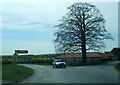
10
Looking to Kennels Farm
Looking NW, a representative view of this area.
Image: © Stephen Horncastle
Taken: 4 Mar 2006
0.19 miles