IMAGES TAKEN NEAR TO
Eddlethorpe, MALTON, YO17 9QS
Introduction
This page details the photographs taken nearby to YO17 9QS by members of the Geograph project.
The Geograph project started in 2005 with the aim of publishing, organising and preserving representative images for every square kilometre of Great Britain, Ireland and the Isle of Man.

There are currently over 7.5m images from over14,400 individuals and you can help contribute to the project by visiting https://www.geograph.org.uk
Image Map
Images are licensed for reuse under creativecommons.org/licenses/by-sa/2.0
Notes
- Clicking on the map will re-center to the selected point.
- The higher the marker number, the further away the image location is from the centre of the postcode.
Image Listing (11 Images Found)
Images are licensed for reuse under creativecommons.org/licenses/by-sa/2.0
Image
Details
Distance
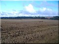
1
NW of Kennythorpe
Looking west, a typical scene of this grid square.
Image: © Stephen Horncastle
Taken: 4 Mar 2006
0.06 miles
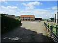
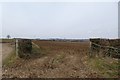
2
Field barn straddling the boundary of two fields, Eddlethorpe
Image: © Jonathan Thacker
Taken: 26 May 2019
0.11 miles
3
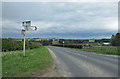
Road to Norton-on-Derwent
Right turn to Langton and North Grimston.
Image: © Pauline E
Taken: 24 Apr 2012
0.16 miles
4
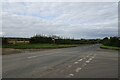
Junction and road signs
Looking towards Malton along the Old Malton Road.
Image: © DS Pugh
Taken: 23 Sep 2023
0.17 miles
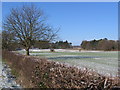
5
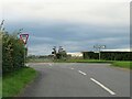
Road junction in Burythorpe parish
At this point a minor road from Langton meets the Stamford Bridge to Norton road, which might be an unclassified county road but is often busy with traffic.
Image: © Gordon Hatton
Taken: 14 Oct 2022
0.17 miles
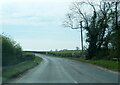
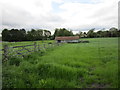
7

Road near Eddlethorpe
Looking along the Old Malton Road.
Image: © DS Pugh
Taken: 23 Sep 2023
0.19 miles
8
Farmland next to the Westow junction
Looking into a field off the old Malton road.
Image: © DS Pugh
Taken: 7 Apr 2013
0.21 miles