IMAGES TAKEN NEAR TO
Langton, MALTON, YO17 9QJ
Introduction
This page details the photographs taken nearby to YO17 9QJ by members of the Geograph project.
The Geograph project started in 2005 with the aim of publishing, organising and preserving representative images for every square kilometre of Great Britain, Ireland and the Isle of Man.

There are currently over 7.5m images from over14,400 individuals and you can help contribute to the project by visiting https://www.geograph.org.uk
Image Map
Images are licensed for reuse under creativecommons.org/licenses/by-sa/2.0
Notes
- Clicking on the map will re-center to the selected point.
- The higher the marker number, the further away the image location is from the centre of the postcode.
Image Listing (18 Images Found)
Images are licensed for reuse under creativecommons.org/licenses/by-sa/2.0
Image
Details
Distance
1
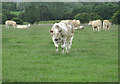
Bullocks near East Farm
Grazing pasture off Toftings Lane.
Image: © Pauline E
Taken: 1 Jul 2013
0.10 miles
4
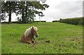
He's just woken up
I thought he was dead when we approached but he soon sat up and started to take notice. Close to East Farm.
Image: © Pauline E
Taken: 1 Jul 2013
0.19 miles
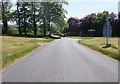
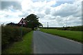
6
Langton Crossroads
Looking south towards Toftings Lane.
Image: © DS Pugh
Taken: 11 Jun 2017
0.21 miles
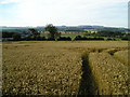
9
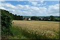
Barley near Langton Crossroads
Looking across a field of barley towards Toftings Lane.
Image: © DS Pugh
Taken: 23 Jun 2020
0.21 miles
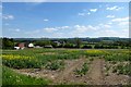
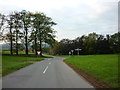
10
Approaching Langton Crossroads
Looking along Cordike Lane.
Image: © DS Pugh
Taken: 23 Jun 2020
0.21 miles