IMAGES TAKEN NEAR TO
Burythorpe, MALTON, YO17 9LF
Introduction
This page details the photographs taken nearby to YO17 9LF by members of the Geograph project.
The Geograph project started in 2005 with the aim of publishing, organising and preserving representative images for every square kilometre of Great Britain, Ireland and the Isle of Man.

There are currently over 7.5m images from over14,400 individuals and you can help contribute to the project by visiting https://www.geograph.org.uk
Image Map
Images are licensed for reuse under creativecommons.org/licenses/by-sa/2.0
Notes
- Clicking on the map will re-center to the selected point.
- The higher the marker number, the further away the image location is from the centre of the postcode.
Image Listing (61 Images Found)
Images are licensed for reuse under creativecommons.org/licenses/by-sa/2.0
Image
Details
Distance
1

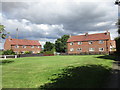
Burythorpe cricket ground
A sports field with facilities for cricket, football and a children's play area.
Image: © Gordon Hatton
Taken: 18 Feb 2019
0.05 miles
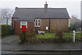
6
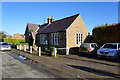
Village Hall, Burythorpe
Former Village School.
Image: © Ian S
Taken: 8 Nov 2017
0.09 miles
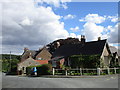
8
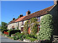
Burythorpe
Burythorpe is in the top NW corner of the grid square which is all farmland. Looking south, a typical view of the cottages in this village.
Image: © Stephen Horncastle
Taken: 3 Jun 2006
0.10 miles
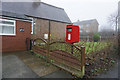
9
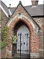
Burythorpe Village Hall (former School) entrance + defibrillator
Built in 1857 Pevsner calls this a "Pointed-arched porch
Image: © Martin Dawes
Taken: 3 Apr 2019
0.10 miles
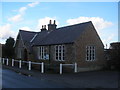
10

Burythorpe Village Hall (former School) built 1857
Image: © Martin Dawes
Taken: 3 Apr 2019
0.10 miles