IMAGES TAKEN NEAR TO
YO17 9FR
Introduction
This page details the photographs taken nearby to YO17 9FR by members of the Geograph project.
The Geograph project started in 2005 with the aim of publishing, organising and preserving representative images for every square kilometre of Great Britain, Ireland and the Isle of Man.

There are currently over 7.5m images from over14,400 individuals and you can help contribute to the project by visiting https://www.geograph.org.uk
Image Map
Images are licensed for reuse under creativecommons.org/licenses/by-sa/2.0
Notes
- Clicking on the map will re-center to the selected point.
- The higher the marker number, the further away the image location is from the centre of the postcode.
Image Listing (16 Images Found)
Images are licensed for reuse under creativecommons.org/licenses/by-sa/2.0
Image
Details
Distance
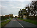
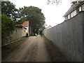
2
Hedgerow beside Bazeley Lane
Looking towards a stables on the edge of Norton.
Image: © DS Pugh
Taken: 11 Mar 2017
0.04 miles
5
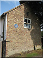
Cottage with blue plaque
Wold Cottage, circa 1840, home to two successful jockeys. See detail Image
Image: © Pauline E
Taken: 25 Aug 2013
0.09 miles
6

John Shepherd and William I'anson Jnr
Blue plaque on Wold Cottage, celebrating the achievements of the above named jockeys.
Image: © Pauline E
Taken: 25 Aug 2013
0.09 miles
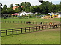
7

Bridleway near Howe Hill
There are many racing stables in the area.
Image: © Pauline E
Taken: 25 Aug 2013
0.14 miles
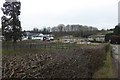
9

Field along Bazeley's Lane
Looking across farmland on the edge of Norton.
Image: © DS Pugh
Taken: 5 Sep 2021
0.15 miles
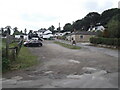
10

Blink Bonny Stables
Looking along a bridleway passing the stables.
Image: © DS Pugh
Taken: 5 Sep 2021
0.17 miles